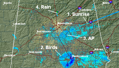
Variety on radar this morning
Area radars are lit up with many different phenomena this morning. Below is a still image from the Birmingham NEXRAD around sunrise with things labeled.
1. Sunrise. The radar sends out microwave energy that bounces off of raindrops, etc. This is how it detects rain. When the sun rises, it has some energy in the microwave frequency, so as it passes the low angle of the radar (0.5 degrees above the horizon), it thinks the incoming sunlight is its own energy being reflected off of raindrops. This creates a spike in the direction of sunrise. This is repeated at sunset.
2. Birds taking off. Multiple areas of birds taking off from their roosts. For a more detailed discussion, see last week’s blog on birds on radar.
3. Ground clutter/anomalous propagation. When there is a temperature inversion early in the morning, the radar beam gets bent toward the ground, and picks up insects, trees, and other low-level targets at much greater distances from the radar than it does in the day when the radar beam travels along a more normal path.
4. Rain shower. Just east of I-65 in near Garden City and Hanceville it has rained this morning.
Category: Met 101/Weather History


