Heat bursts
Jamie Sandford asked for a discussion of the physics of “heat bursts,” a fascinating weather phenomenon that has been observed several times this year in the Plains (see Bill Murray’s recent post on some intense heat bursts here.
A heat burst occurs when an intense thunderstorm downdraft reaches the ground despite becoming dry before reaching the surface. When air descends in the atmosphere, the pressure on it increases. When the air is compressed like this, it warms, much like when you put air in a tire, or like the outside compressor on an air conditioner.
Normally, when air descends in a thunderstorm downdraft, evaporation of raindrops cools the air and offsets the adiabatic, or compression warming. But, if the downdraft is dry, it warms very quickly, at the rate of 5.5 degrees F for every 1,000 feet of descent. So, if a downdraft is 75 degrees at 3,000 feet without water, it will be 92 degrees when it reaches the ground. This causes the heat burst.
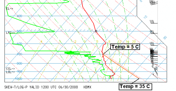
Above is the balloon data from Birmingham this morning on a skew-T, log-p chart. The red line is the temperature profile with height. If air in a downdraft originated at 700 mb (about 10,000 feet), it is 5 C (41 F). The dashed diagonal red lines indicate how air cools or warms adiabatically due to compression or expansion. So, that air would be 35 C (95 F) if it came down to the ground.
Interestingly, notice that the air at 300 mb (about 25,000 feet, a low level for a commercial jet to fly) has a temperature of -35 C (-31 F). When this air is brought into the airplane, it has to be compressed to 850 mb, which warms it, today, to about 124 degrees F! So, even though it’s -31 degrees outside, the plane has to be air conditioned. Neat stuff.
Category: Met 101/Weather History


