Cold Air, Rare Radar Pictures
Some very cold air is moving in to the United States early this morning, as JB had predicted last week, but it doesn’t look like the core of it will head south as much as it will head east. But, some of it is coming south this morning, and we will get a colder surge by Wednesday.
Some temperatures at 3 am, heading up I-65 first. Birmingham 33, Huntsville 29, Nashville 22, Louisville 14, Indianapolis 7, Chicago -3. It gets colder in Wisconsin and Minnesota. Milwaukee -4, Green Bay -8, Augusta, WI -13, International Falls, MN -34. Wow.
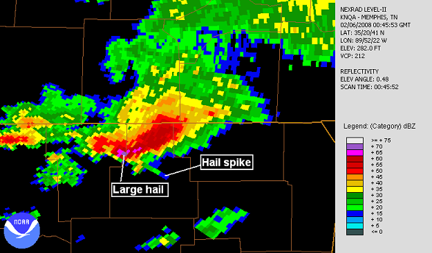
Looking back at some interesting radar pictures from last week’s tornado outbreak. The first one is a “hail spike”. This occurs when the radar energy bounces off large hailstones down to the ground, back up to hailstones in the same storm, then back to the radar. It usually takes fairly large hail to do this. The radar calculates the range, or distance from the radar of an object by how long it takes for the power to return. Since this power has bounced around, the radar thinks it’s farther away. This creates a spike of radar reflectivity beyond where the large hailstones really are. This occurred in a storm in northern Mississippi Tuesday evening, shown below.
Another interesting radar picture comes from a supercell storm near Guntersville, Alabama, early Wednesday morning. Sometimes, when the updraft in a storm is very strong, raindrops and hailstones are not able to form fast enough to be detected by radar until they reach higher levels. This forms a “weak echo region”. Sometimes, in the areas of weaker updraft surrounding this, rain shows up around a circular pattern, like a “doughnut”. This is called a bounded weak echo region (BWER). It may also have to do with the rotation in the updraft, centrifuging large raindrops out of the area. Before Doppler radar, this was one of the best radar indicators of a tornado the NWS used.
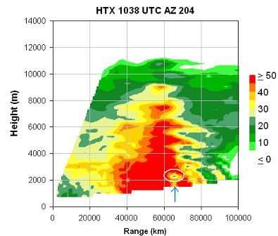
The first image is a vertical cross-section (looking from the NW) through the storm. Note the weak area of echo beyond 60 km.
It shows up somewhat near the hook echo in a normal, plan view of radar reflectivity at low-levels.
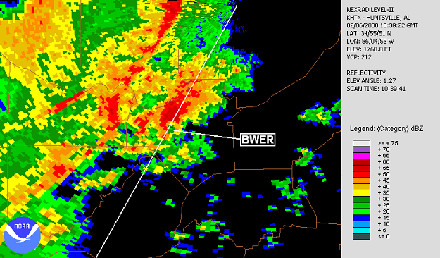
It shows up even better at a higher elevation angle plan view, looking higher up in the storm.

Category: Uncategorized
About the Author (Author Profile)
Subscribe
If you enjoyed this article, subscribe to receive more just like it.


