Active Afternoon Ahead
You couldn’t ask for a more splendid looking summer Sunday morning in Alabama with nearly totally blue skies. Temperatures are warm, already in the middle 80s and humidities are high, with dewpoints around 70F.
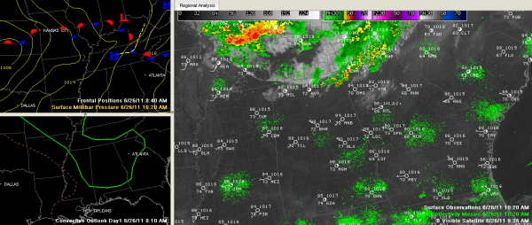
But I think we are in for an active weather afternoon across the region with strong thunderstorms. The SPC has much of Alabama as far south as Jackson, Andalusia and Ozark in a slight risk outlook for severe weather today.
An overnight complex of storms over the Ohio Valley dropped southeast and then turned east as predicted and weakened. But it is serving to lay down a mini-frontal boundary that is clearly evident on Doppler radars and visible satellite photos late this morning. That boundary had sunk to near the Tennessee River. It will sink a little further south and stall eventually over North Central Alabama.
The airmass over Alabama is already unstable and will become more unstable as the day goes on. CAPEs will be between 3000-4000 j/kg again this afternoon, providing plenty of energy for storms. Moisture levels are high too, which gives them that extra octane. There is a small amount of general wind shear in the atmosphere, just enough to keep them from choking on their own precipitation, but not enough for them to become supercells or produce tornadoes.
The wet bulb zero heights are a little high for large hail, but there is going to be enough instability in the hail formation regions for there to be some hail.
Of course, lightning will be a big threat and can be deadly.
Heavy rains will result from slow storm motion and backbuilding of storms over the same areas. This could result in localized flooding.
Of course, strong gusty winds will result and the stronger storms will produce microbursts that can down tree limbs, uproot trees and even cause structural damage.
If you find yourself in the path of a storm or hear one form near you, go inside before it arrives.
Category: Alabama's Weather, Severe Weather


