Beware the BWER
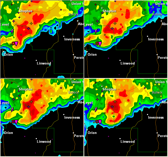
A beautiful example of a bounded weak echo region BWER) tonight in the Pike County storm that is now moving into Bullock County.
These four simultaneous scans are from the Maxweell AFB radar just after 10 pm tonight.
The radar elevations from top left going clockwise…
1. 0.5 degree tilt or about 2500 feet above surface at the BWER
2. 1.3 degree tilt or about 4500 feet above the surface
3. 2.4 degree tilt or about 7700 feet above the surface
4. 3.1 degree tilt or about 9600 feet above the surface
See the scalloped clear area on the two lower scans on the southeast side of the storm.
A BWER is a radar signature that is trongly indicative of a severe thunderstorm.
The BWER is a vertical column of weak or non-existent radar echoes that is surrounded on the sides and top by very strong radar echoes. It is the vault, which is observed on the southeast flank of a severe storm. There is an overhang above it.
It is an updraft that is so strong that it is blowing the forming hydrometeors to higher altitudes before they are large enough to be detected by radar, creating the vault or overhang. A large concentration of rain and hail is held suspended aloft by the upward air current.
Big hailstones are born here, and ejected outward upwind if it is an organized storm.
Beware the BWER.
Category: Uncategorized


Comments (1)
Trackback URL | Comments RSS Feed
Sites That Link to this Post