Remembering 2001’s Tropical Storm Allison
On June 5, 2001, ship, buoy and recon reports indicated that a tropical storm had formed in the Gulf about 80 miles south of Galveston. It had top winds of 60 mph. Twelve hours later, it made landfall near the west end of Galveston with 50 mph winds. 8-12 inches of rain fell across Galveston and Harris Counties that night. The storm drifted north to near Lufkin on the 6th. The storm was being steered northward slowly by the subtropical high over Florida. That high weakened and the steering currents collapsed. The center of the remnants of the storm described a loop. An additional 8-12 inches of rain fell across parts of Harris County. On Friday the 8th, the system was moving south again. More heavy rain fell across the Houston area that morning, but skies cleared by lunch and as sun heated the atmosphere, it was evident that there were going to be problems.
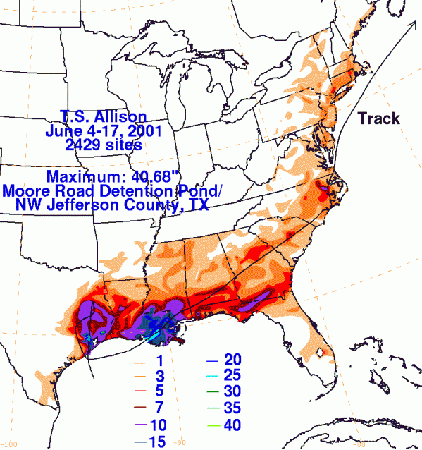
Thunderstorms formed during the afternoon, fueled by a strong inflow on the eastern side of the circulation of the remnant low. The storms merged into a huge complex over the city of Houston. Flash flooding began during rush hour. By late evening, every major road and interstate in Houston was underwater. The University of Texas hospitals were being inundated. Torrential rains fell for over 10 hours across the city. Rainfall rates averaged four inches per hour in spots. Twenty inches of rain fell in Green’s Bayou. 35-40 inches of rain fell in Northwest Jefferson County. 36.99 inches was reported at the Port of Houston. Houston’s six day total was 38.6 inches. When all was said and down, 30,000 people were left homeless in the Houston area. 73,000 homes were flooded. 95,000 vehicles were destroyed. A total of 99 flash flood warnings were issued by the National Weather Service in Houston.
But Allison was not finished. The center drifted back into the Gulf of Mexico, just 22 miles west of where it had originally made landfall. The system developed subtropical characteristics after moving back over water. It turned east and headed toward Louisiana, making landfall on the 11th. It actually intensified over land and became a subtropical storm. Winds increased to 45 mph and the system actually developed an eye feature. A total of 29.86 inches of rain fell in Thibodeaux, causing more incredible flooding. The system moved across Mississippi and Alabama, dumping up to ten inches of rain in spots. Five people drowned in rip currents off the Northwest Florida coast. Allison’s remnants eventually stalled over North Carolina after producing severe weather in Georgia. It finally moved out to sea on the 17th, where is briefly re-attained subtropical storm status.
Damage totaled $5.5 billion, making Allison the most costly tropical storm in history. Allison is the only tropical storm to have its name retired. A total of 41 people were killed.
Category: Met 101/Weather History


Comments (2)
Trackback URL | Comments RSS Feed
Sites That Link to this Post