Hot For A While
Summer’s official calendar start-date is June 21st at 12:16 PM Central Time, but since most folks look at Memorial Day as the first holiday of Summer (and since it feels like it anyway), I think it’s safe to declare that Summer has arrived in Alabama. How often do we associate highs in the mid-90s with “Spring” anyway?
Looking ahead at some long-range computer guidance, the next few weeks look to be hotter than what the thirty-year averages say we should have for late May and early June. For example, today’s average high for Birmingham is 84 degrees; the Birmingham Airport reached 87º at 9:53 AM. So long, normal! We will be flirting with record highs for the next few days until the upper-air ridge relaxes a little and allows for a few scattered afternoon and evening thunderstorms. (Upper-air ridges like the one we are under now deflect stormy weather and cause subsidence, a sinking motion in the atmosphere that causes the air to warm and dry as it descends).
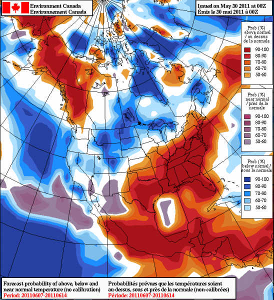
Here is the GEMS (Environment Canada) North America temperature anomaly forecast through June 14th:
This is an anomaly probability map; it is showing more along the lines of where above-normal temperatures are likely as opposed to just how much above-normal the temperatures will be.
We do expect a brief break from the mid-summer kind of heat by the weekend as the ridge weakens and scattered afternoon and evening storms help knock temperatures back to the lower 90s for highs. (That’s what storms are for, by the way…they serve to help balance the atmosphere!)
Edited at 7 PM to correct the average temperature for Birmingham
-Jason
Follow me on Twitter: @simpson3340
Facebook: Jason Michael Simpson
Category: Hodgepodge


