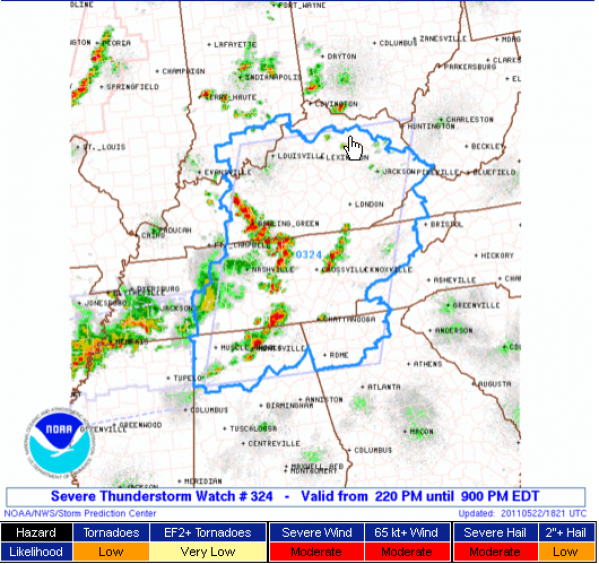
Severe Thunderstorm Watch North Alabama…
What do we always say about thunderstorms in Alabama?
Expect the unexpected.
Showers and storms fired late this morning over Northwest Alabama as an outflow boundary from old storms settled into the area and exploited the heat and humidity present.
The result has been scattered strong storms from Marion County northeastward to the Huntsville area. A severe storm in the Huntsville area has prompted a severe thunderstorm warning and now a tornado warning. Huntsville area spotters report wall cloud near Drake and Patton with rotation….moving east….
The NWS warns that storms could become severe over Northwest Alabama and the Tennessee Valley this afternoon and is about to issue a severe thunderstorm watch that will include Winston and Marion County in the Birmingham office’s area of responsibility. Here it comes now. It includes the following counties in the HUN warning area: Franklin, Lincoln, Moore [TN] and Colbert, Cullman, DeKalb, Franklin, Jackson, Lauderdale, Lawrence, Limestone, Madison, Marshall and Morgan.
The watch will be in effect till 8:00 PM CDT.
The airmass over North and Central Alabama is unstable with the heat and humidity, but this is not going to be a significant severe weather episode. The SPC says the threat of tornadoes is low and the threat of strong tornadoes is very low. The most significant threats are from damaging winds and hail larger than one inch.
The storms over Marion County actually weakened as they moved into Franklin and Lawrence Counties and they were not especially heavy to start with.
Category: Alabama's Weather, Severe Weather


