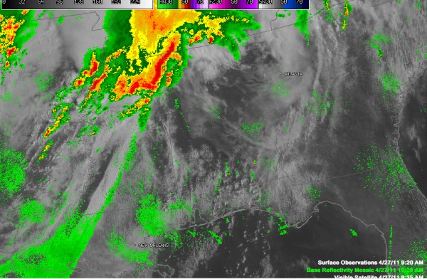
Severe Weather Update – 10:20 a.m.
Look at the clearing in the I-20/59 corridor across Central Alabama. This will allow for a quick warm up and build up of instability, aided by the influx of moisture and colder temperatures arriving aloft.
Some quick notes…
Let’s go by NWS Office…
BIRMINGHAM
…A fatality reported in Moody…one female…trees down on mobile home from thunderstorm wind damage…
…No warnings right now
…Radar is clear…storms that just moved into western Marion County are not severe. But a severe thunderstorm warning just issued for Lamar and Marion for the big storms back a little further.
…The Winfield NOAA Weatheradio transmitter is off the air…do not know when it will be restored…it is a communications problem
HUNTSVILLE
…Severe thunderstorm warning for northern Madison County…storm passing into Tennessee north of Hazel Green…this storm had a tornado warning on it earlier
…Severe thunderstorm warning for Franklin and Colbert Counties…storms moving out of Mississippi will affect much of these two counties…
…New tornado warning for Franklin County for that storm coming out of Tishomingo County…it will move toward Florence…
…Another new tornado warning just issued for Colbert and Franklin County…it replaces the earlier warning for Franklin and takes into account the more eastward movement of the cell…keeping Florence safe
…Also strong storms over western Lauderdale County…but they are below severe limits for now
…New flash flood warning for Lauderdale, Colbert and Franklin Counties. Rainfall amounts are estimated around 2 inches according to Doppler radar…with some 3 inch amounts near Waterloo…
LATE ADDITION
A new tornado watch (#231) has been issued for extreme North Alabama (including Jackson County) and much of southern Tennessee over into southwestern North Carolina.
MEMPHIS
…Has issued a tornado warning for Itawamba, Prentiss and Tishomingo Counties in Northeast Mississippi for rotation Baldwyn MS…this storm will move toward northwestern Franklin County…and into Colbert County…several counties surrounding this warning have a severe thunderstorm warning…
…Widespread heavy thunderstorms over Northern Mississppi extending back west of these storms…from Tupelo to Pontotoc to Oxford and Batesville…a severe thunderstorm warning is in effect for areas around Pontotoc and Tupelo…begin to see some interesting storm structure southwest of Pontotoc…
…Storms are growing rapidly back in eastern Arkansas and near the Mississippi River…Memphis will deal with some big hailstorms between now and lunch time. A severe thunderstorm warning was just issued for the Memphis area.
…Several flash flood warnings across northern Mississippi
…10:28…couple of trees down at Barnes Crossing in Tupelo…some street flooding also…this storm is about to move into Marion County
JACKSON
…Watching a line of showers extending from west of Aberdeen to west of Starkville to Louisville…south southwestward to east of Jackson to Brookhaven. Will be interesting to see if this develops.
…More storms are trying to form over the Delta…but tey seem to be having a hard time…probably a little cap there still to be overcome…won’t be hard with all the cold air aloft…
Category: Alabama's Weather, Severe Weather


