Analysis 930 am
…MAJOR TORNADO OUTBREAK STILL COMING THIS AFTERNOON…
The line of storms this morning was just a precursor to the bigger event we are expecting later today (see JB’s post below). The storms that knocked down thousands of trees and powerlines, and produced widespread 50-75 mph wind gusts, stabilized the atmosphere temporarily, so we should get a break over all but extreme NW Alabama for a few hours this morning.
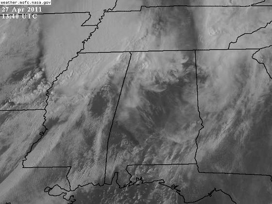
However, the sun is already coming out over much of Alabama. Check out the visible satellite picture (or look out the window).
Sunshine will warm temperatures quickly this morning through the 70s, and it will reach the lower 80s by afternoon. However, the morning balloon data from NWS Birmingham showed very cold air aloft. And, even though dewpoints dropped to the upper 50s as the thunderstorms mixed up the atmosphere, they are already rising, and will rise throughout the day. As the sun continues to heat the atmosphere up, the 70 mph winds at 3,000 feet will start to get mixed with the surface layer winds, so gradient winds will get very gusty by late morning, probably 30 mph at times. And those winds will be out of the south, bringing in Gulf moisture (dewpoints in SW Alabama are in the 70s). Once we get warm, humid air back in place at the surface by noon or so, with cold air aloft, the air will be very unstable. CAPE values (atmospheric potential energy) will reach 3,000 to 5,000 J/kg, supporting strong updrafts and intense storms this afternoon.
The other problem is the wind shear. The main upper-level system will approach by late afternoon. Winds will increase in speed and change direction with height, creating spin about a horizontal axis. Storm updrafts will tilt this rotation into the vertical (like a spiraling football getting tipped at the line of scrimmage), producing rotating storms. The helicity, or a measure of this wind shear, will also be very high, between 300 and 600 m2/s2. It is rare to see this much wind shear in an almost summerlike environment with warm, humid air like this.
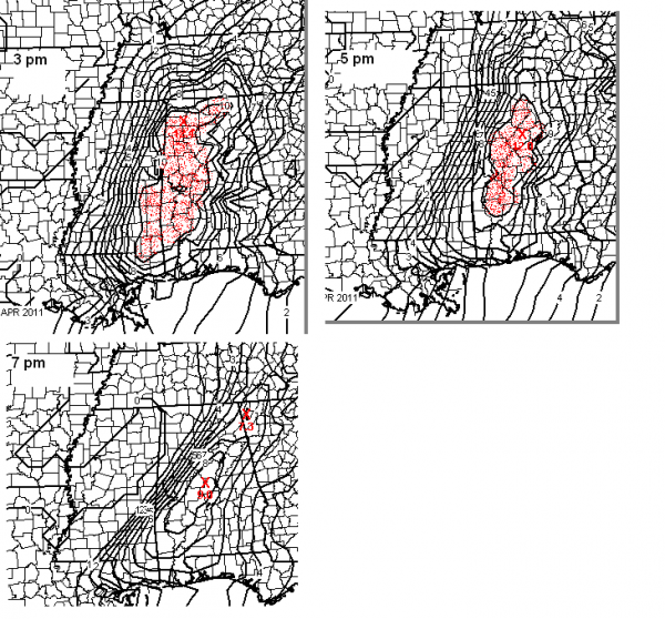
The combination of extreme instability (like we see on summer afternoons) and extreme wind shear (like we see often in winter) will create a very dangerous setup over Alabama this afternoon. The energy-helicity index (a combo of CAPE and wind shear) measures the overall tornado potential well. Anything over 2 means tornadoes are possible, and over 5 tornadoes are likely. On April 8, 1998, the EHI was around 6. Today, as you can see on the maps below for 3, 5, and 7 pm, we expect EHI values of 8-10 over much of north and central Alabama, some of the highest I’ve ever seen.
The red areas are EHI’s of 10 or higher…a rare number.
Clearly, with this kind of shear and instability building, very intense storms will form, and almost all of them will rotate. In this environment, numerous tornadoes will likely occur, and some of them may be violent tornadoes. Please take this weather event as seriously as you ever take an event. If a tornado warning is issued, don’t mess around, execute your tornado plan.
UPDATES SAFETY RULES:
At work, in large buildings, interior hallways on the lowest floors and stairways are often best. Stay away from windows and outside doors. In smaller offices, go to the lowest floor, in an interior room, away from windows and doors. If you work in a big office building, you may be safer staying at work until the storms move on through this evening.
In the home, the underground part of a basement is best, but get under a work bench, heavy table, etc. Stay away from garage doors! They are a weak point on your house in winds. If you don’t have a basement, go to the lowest floor, interior room or hallway, away from windows, doors, and outside walls. Hall closets, if on interior walls, are good. Protect your head. Put batting helmets, football helmets, bicycle helmets on the kids. Stay low. Falling trees can come through the roof, but often stop before coming all the way through.
In mobile homes, leave. All (or almost all) of the fatalities in April 15 tornadoes in Alabama were in mobile homes. If you live in a mobile home, today is the kind of day to just go ahead and leave around noon and stay with friends, etc. in a more substantial structure until the storms are over tonight.
There is no reason to panic. Just have a plan ready, follow the weather, and if a warning is issued, execute your plan.
Brian and I are about to head up I-22…we’ll have updates from the road.
Category: Severe Weather


