Analysis 1030 pm
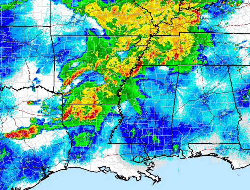
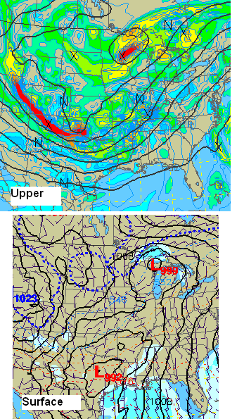
Very complex and dangerous weather situation over the SE US tonight. Large upper trough over central US, with surface low in south Texas. Supercell storms and MCS’s (areas of storms) are spread from Texas to Kentucky. A lot of red on the radar tonight, and reports of very large hail, wind damage, and tornadoes have been received.
As for the rest of the night, the storms in AR and LA should move into MS, and maybe extreme NW AL (see tornado watch for NW AL below). However, the air is a little more stable farther east here in central AL, and most of the forcing should stay northwest of Smith Lake and HSV until sunrise. Still, we can’t rule out an isolated storm popping up in west Alabama tonight, so leave the weather radios on standby.
By tomorrow morning, one low will be in TN, but as the main upper-level trough approaches, a new one will likely develop over AR/MS. The flow into the new low will increase wind shear over Alabama tomorrow afternoon. With strong upper-level winds changing direction with height, we will see helicity values (shear that produces storm rotation) of 250-500 m2/s2, with the highest values over north Alabama, north of I-20.
It will also be warm and humid near the ground and cold aloft, so the air will be unstable, favorable for storm development. Just how unstable we don’t know yet…it will depend some on how much cloud cover blows over from storms to our west. The sun will still heat the ground even through high clouds, and since we’ll start the day near 70 degrees, it won’t take much sun to reach the 80s. This will likely occur, producing CAPE energy values of 3,000 to 5,000 J/kg over Alabama.
So, with the combination of extreme instability and high wind shear, storms will move in/develop over west Alabama, possibly by late morning. Storms will overspread north and central Alabama during the afternoon hours. Exactly where storms form is hard to say, as it will depend on where boundaries are set up from tonight’s storms when they weaken. But, assuming we get a little sunshine, the conditions will be very favorable for intense, rotating storms and tornadoes. Large hail is also likely. The energy-helicity index, a measure of the best combination of wind shear for storm rotation and instability for storm growth, is shown below for 4 pm tomorrow (computer model). Anything above 1 is supportive of tornadoes, and above 3 indicates a serious threat for large tornadoes.
The area above 3 covers all of Alabama north of I-20 and all of Alabama west of I-65. The areas farther south are not as likely to pan out due to less shear, but all of north Alabama is under the gun. Mainly, nothing has changed since noon. There is the potential for a major tornado outbreak tomorrow afternoon, with the highest threat north of I-20. I wouldn’t be surprised if a high risk is issued by SPC for us tomorrow.
This is a serious situation. Have a plan for what you will do in a tornado warning at work, at home, wherever you will be. The schools mainly have tornado plans in place. Keep an eye on the weather carefully through Wednesday night.
At work, in large buildings, interior hallways on the lowest floors and stairways are often best. Stay away from windows and outside doors. In smaller offices, go to the lowest floor, in an interior room, away from windows and doors.
In the home, the underground part of a basement is best, but get under a work bench, heavy table, etc. Stay away from garage doors! They are a weak point on your house in winds. If you don’t have a basement, go to the lowest floor, interior room or hallway, away from windows, doors, and outside walls. Hall closets, if on interior walls, are good. Protect your head. Put batting helmets, football helmets, bicycle helmets on the kids. Stay low. Falling trees can come through the roof, but often stop before coming all the way through.
In mobile homes, leave. All (or almost all) of the fatalities in April 15 tornadoes in Alabama were in mobile homes. If an outbreak starts, try to go ahead and go to a sturdy building ahead of time and wait it out. You are better off in a ditch than in a mobile home.
There is no reason to panic. Just have a plan ready, follow the weather, and if a warning is issued, execute your plan.
Brian Peters and I will be out storm spotting tomorrow with a camera. We plan to head initially up I-22 (unless things change) toward Tupelo, and start to move back south and east ahead of the storms.
One more neat thing tonight…check out this radar loop from Mobile. The bugs came out after sunset, but the strong south winds are pushing them inland, away from the beach, and even mainly out of Mobile Bay!
Category: Severe Weather


