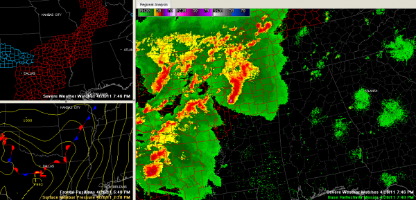
Outbreak Underway
A severe weather outbreak is occurring over the Arklatex and Mid South tonight and it is expected to get worse as upper level winds intensify during the evening.
Let’s summarize some of the bigger storms…
NORTHWEST LOUISIANA/NORTHEAST TEXAS
…possible tornado on the ground now near Blanchard, northwest of Shreveport…moving northeast toward Benton…rotation is increasing…
…another potentially tornadic supercell is southwest of that one…passing south of Carthage TX…it will pass south of Shreveport and north of Mansfield between 8-8:15 p.m.
NORTHEAST MISSISSIPPI
…all clear now…a tornado watch has been issued for the northwestern Mississippi storms that are moving east northeast. This area could be affected in 90 minutes or so.
NORTHWEST MISSISSIPPI
…several tornado warnings for multiple severe storms in a short line extending from downtown Memphis to north of Clarksdale…cities that could be affected include: Byhalia, Senatobia, Batesville, Sledge and Holly Springs.
ARKANSAS
…one of the most dangerous storms is about 40 miles south of Little Rock now…it is moving toward Pine Bluff and shows strong indications of a tornado…a funnel cloud was just reported near Pine Bluff.
FOR ALABAMA
One developing shower was over Madison County in North Alabama. Another was over Fayette County. We could see a few more showers and perhaps even a stray thunderstorm this evening, but the main activity will come in two waves tonight. The first will be the storms over northwestern Mississippi that may reach the Quad Cities around 10 p.m. tonight. Then, the activity in northwestern Louisiana could reach other parts of Northwest Alabama, around Lamar/Marion Counties after 2 a.m.
Category: Alabama's Weather, Severe Weather


