What to Expect
What to expect:
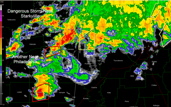
We will continue to see thunderstorms form over eastern Mississippi and stream into West Central Alabama for the next few hours. The airmass will gradually become more unstable and the storms will become more intense into Alabama. Right now, we are carefully watching storms near Philadelphia MS that could affect Sumter and Greene Counties…as well as storms east of Starkville that will affect Lamar and northern Pickens shortly. Both storms are severe and potentially tornadic.
The storm heading toward Sumter and Greene Counties looks especially dangerous and the airmass is quickly becoming more unstable over West Central Alabama.
Southwest Alabama upercells, including the tornadic one in Marengo County will continue to affect areas mainly south of a line from Demopolis to Marion to Clanton to Alex City through the afternoon.
A new tornado warning has just been issued for Dallas, Marengo and Perry Counties for the confirmed tornado near Thomaston.
FOR THE NEXT SEVERAL HOURS:
Look for storms to really intensify in the I-59 corridor from Meridian MS to Birmingham to Gadsden between 4 and 8 p.m.
The back edge of the storm will begin to sweep east from the Alabama/Mississippi border starting about 9 p.m, reaching I-65 and Birmingham around 11-midnight and out of Cleburne County into Georgia about 3 a.m.
Category: Alabama's Weather, Severe Weather


