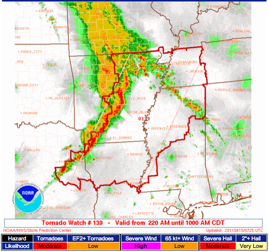
Tornado Watch to the West
A Tornado Watch is up until 10 AM for much of northern Mississippi as well as parts of western Tennessee, Arkansas, Louisiana, and northeast Texas. Thunderstorms are still rumbling across Arkansas this morning, and they will progress into the watch area over the next 6-7 hours. Additional strong and severe storms are likely farther south and east later today; we expect the main window for severe weather in Alabama to come in the afternoon and evening hours.
The Storm Prediction Center maintains a *MODERATE* Risk of severe weather for a large part of Alabama for later today. That means we expect to have a watch at some point followed by severe thunderstorm development in the afternoon.
There have been a lot of questions about what we expect will be the worst threat, how bad will it get, etc. Unfortunately, we cannot be extremely specific on a point-by-point basis. Thunderstorms are small relative to the size of the atmosphere, and the tools we use to measure the atmosphere cannot adequately detect every single characteristic to the point where a highly-specific forecast can be made. Tornadoes, damaging wind gusts, large hail, and heavy rain could be associated with any storms that develop today, so the best advice is just to stay aware of the situation with us on the blog and on television throughout the day.
Unlike Monday, there is a much higher potential for tornadoes within storms today. Not all storms are severe, and not all storms produce tornadoes; we have to take them on a case-by-case basis and watch it closely.
-Jason
Follow me on Twitter: @simpson3340
Category: Severe Weather


