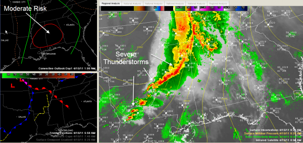
Updating the Situation at 8:45 a.m.
Here is the latest just at 8:30 a.m.
A line of intense thunderstorms moved east out of Oklahoma and Arkansas overnight after producing killer tornadoes in the Sooner State. It crossed the Mississippi River early this morning and is now knocking on the door of Northwest Alabama. It is weaker than last night, but still producing damaging winds and hail. It is slowing down and will run likely stall over North and Northwest Alabama.
These storms could begin affecting Marion and Franklin Counties in Northwest Alabama within the hour and warnings may be required. There are numerous severe thunderstorm warnings in northeastern Mississippi at this time. Storms are very intense just west of Starkville. We just received a damage report from LeFlore County MS that said “emergency mngr reports TSTM WND DMG at 06:13 AM CDT — update…one trailer was destroyed and another lost the roof and skirting. multiple trees and power lines downed…and fences were downed in the area.” These same storms are approaching Starkville now.
You’ll probably see warnings for Marion and Lamar Counties within the next 30 minutes.
In addition to the squall line over Mississippi, storms developed ahead of a northward moving warm front during the pre-dawn hours over Northwest Alabama. Those storms extend from Blount and Cullman Counties northwestward into Lawrence County and the Shoals area. These storms are prodigious lightning and heavy producers and could produce some hail. Don’t expect them to become severe.
But they are the advance guard of warm, moist air that is moving northward. This will make the airmass over Alabama and Mississippi increasingly unstable as we go through the day. The NWS Jackson warns that their morning balloon sounding already shows a very favorable environment for tornadoes and other severe weather in place over Central Mississippi.
Up at about 18,000 in the atmosphere, very strong winds are moving out of northeast Texas into Arkansas right, rotating through the base of the powerful trough located to our west. These winds will help to grow thunderstorms over Louisiana, Mississippi and southern Arkansas and Tennessee this morning. They will push eastward into Alabama later today. Already seeing more tornado warnings on growing storms back in Louisiana and Central Mississippi.
I think you will see the Northwest Alabama storms lift on northward through the morning hours with little impact. The storms now in Northeast Mississippi will move over into West and Northwest Alabama and stall. Storms will intensify over Louisiana and Central Mississippi through the morning and move into Central Alabama later this morning. Waves of severe storms will then continue until a cold front moves through late this evening, likely preceded by a line of severe storms that will push through the state late this evening.
A tornado watch is in effect for the northwestern parts of Central Alabama and parts of North Alabama until 3 p.m. It does include the Jasper,Tuscaloosa, Birmingham areas. The SPC has much of the state under a moderate risk for severe weather for today. This means there is an enhanced threat of severe weather, including tornadoes, severe hail and damaging winds.
We will be watching the situation throughout the day. Please review your severe weather safety plans and stay close to a reliable source of weather warnings.
Category: Alabama's Weather, Severe Weather


