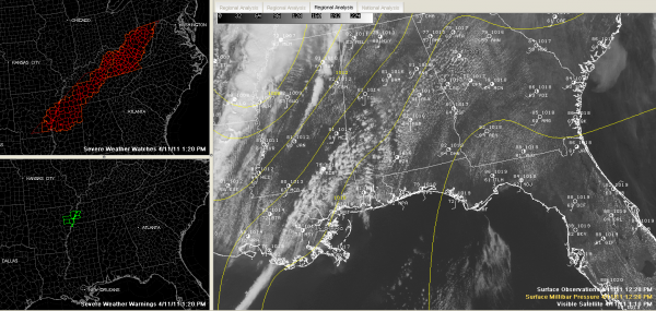
The Alabama Weather Situation at 1:30 p.m.
As we approach 1:30 p.m…here are some notes on the Alabama weather situation.
No watches or warnings for any part of the state now.
In fact, there are no severe thunderstorm or tornado warnings at all right now.
A tornado watch is in effect for northern Mississippi and western Tennessee. A new tornado watch has been issued for eastern Kentucky, SW Virginia into West Virginia.
The SPC upgraded the severe weather risk for today for northwestern Alabama to moderate based on an increased chance mainly for damaging winds northwest of a line from generally Carrollton to Cordova to Hanceille to Scottsboro. Northwest of that line, the chance that any point will see damaging winds within 25 miles is 45%. Most of the rest of Central Alabama has a 30% risk of damaging winds.
The chance of severe hail (1″ or larger) is about 15% north of a line from Tuscaloosa to Calera to Talladega to Heflin.
Everyone get concerned about the tornado threat, and it is about 5% over most of Central and North Alabama, but about 10% over Northwestern Alabama, including parts of Marion, Franklin, Lauderdale and Colbert Counties.
There is a greater threat for tornadoes back over northern Mississippi and western Tennessee, because of a weak low pressure system that formed this morning over western Arkansas that is now straddling the Mississippi River. Easterly surface winds to the right of that low are giving the lower atmosphere more spin, which leads to the higher risk of tornadoes in those areas.
It is beautiful across Central Alabama now, with a good supply of sunshine and puffy cumulus clouds. Temperatures are warm, with readings now in the lower 80s. It is humid, although dewpoints have dropped in the past couple of hours as the atmosphere has turned over a bit and mixed down some slightly drier air.
It’s quite windy, with southwesterly winds averaging 10-20 mph and gusting to over 25 mph at times. Wind advisories are in effect.
The combination of the heat/humidity and upper temperature profiles has made the airmass relatively unstable over North and Central Alabama, as one would expect. CAPEs (or convective available potential energy) readings are in the 500-1000 j/kg range in the I-65 corridor, and between 1000-1500 j/kg over western Alabama. Some 1500 j/kg readings are over northern Mississippi.
As the surface heating continues, the airmass will become more unstable this afternoon, but a decent lid remains on the simmering pot in the form of a capping inversion. This will prevent widespread shower/thunderstorm development ahead of the main line. Having said that, I would not be surprised to see a few showers and perhaps storms develop in next couple of hours from near Meridian MS up through Sumter and Greene Counties up through Shelby and Chilton Counties on on up into East Alabama generally south of I-20.
Also, we do note a line of enhanced cumulus clouds over Mississippi, approaching Tupelo down to Jackson at this hour. There are a few light showers along this line as well. Some are approaching Starkville now. They are having a very hard time getting their act together because of the inversion. We will watch them carefully to see if they are able to develop. They could affect West Aalbama’s Lamar, Pickens and Marion Counties if they do.
The main line of storms is now approaching the Memphis area. It will continue to intensify as it moves east through the afternoon hours. Thunderstorms may reach the northwestern corner of the state by 4 p.m., Marion County by 5 p.m. and Pickens and Lamar Counties by 6 p.m. or so. Folks from Jasper down to Tuscaloosa…timing looks like 7 o’clock or so and shortly thereafter into Jefferson County.
It will be a rough late afternoon and evening across Central Alabama, so monitor the latest developments carefully.
Category: Alabama's Weather, Severe Weather


