Looking West
At 10:11 this morning, the National Weather Service in Little Rock, Arkansas issued a Special Weather Statement for several counties near Little Rock and Pine Bluff. Check out that storm movement:
.SIGNIFICANT WEATHER ADVISORY FOR EXTREME SOUTHERN WHITE…CENTRAL
PRAIRIE…LONOKE…SOUTHEASTERN PULASKI…SOUTHEASTERN SALINE…
NORTHEASTERN GRANT AND NORTHWESTERN JEFFERSON COUNTIES UNTIL 1045 AM
CDT…
AT 1011 AM CDT…NATIONAL WEATHER SERVICE DOPPLER RADAR WAS TRACKING
A STRONG THUNDERSTORM 3 MILES SOUTHEAST OF CANE CREEK…OR 10 MILES
NORTHEAST OF SHERIDAN…MOVING NORTHEAST AT 75 MPH.
HAIL UP TO THE SIZE OF PENNIES AND WIND GUSTS UP TO 40 MPH ARE
EXPECTED WITH THIS STORM…ALONG WITH HEAVY RAIN AND FREQUENT
DANGEROUS LIGHTNING.
Those storms are just ahead of a cold front that is plowing into some very warm, unstable air. Severe weather parameters seem to be maximized over Arkansas, Mississippi, and western Tennessee, and everything is falling into place for this line of showers and storms to intensify over the next few hours, and the Storm Prediction Center has drawn out an area over that region where a tornado watch is likely within the next couple of hours.
The timing on these storms is still a little iffy. That northeast motion at 75 MPH does not indicate that the storms are moving “toward Alabama” at 75 MPH; in fact, the line itself is only progressing east at around 35 to 45 MPH. It should get a boost on to the east this afternoon as the upper-air trough over Oklahoma gets on the move, but no significant rain or storms are likely in Alabama until at least 4 PM today (if not later).
UPDATE 10:32 AM –
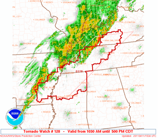
Just as I published this update, the watch box was issued for Mississippi, Arkansas, Kentucky and Tennessee. It runs right up to the Alabama state line, but no Alabama counties are included:
-Jason
Follow me on Twitter: @simpson3340
Category: Severe Weather


