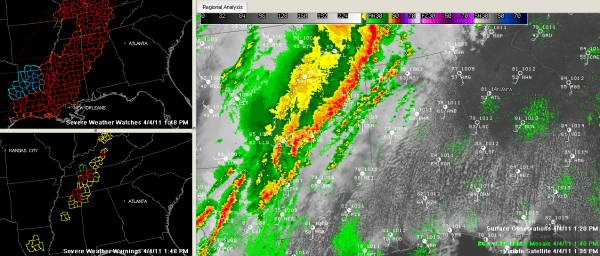
Intense Thunderstorms Approaching Northwest Alabama
An intense line of thunderstorms continues moving east toward western Alabama at this hour. There are numerous severe thunderstorm warnings in Mississippi along this line.
There is even a tornado warning for extreme northeastern Mississippi east of Corinth. This cell will clip extreme northwestern Lauderdale County west of Waterloo.
A severe thunderstorm warning is in effect for Franklin, Colbert and Lauderdale Counties in Northwest Alabama. This is in advance of the strong line of storms over Northeast Mississippi that extends from just east of Corinth to east of Booneville to Pontotoc into Central Mississippi near Grenada and then to near Greenwood.
Thunderstorms have broken out just ahead of the main line of thunderstorms this afternoon from eastern Mississippi into Northwest Alabama. Th storms extend from west of Athens to near Haleyville to Hamilton to near Ackerman in Mississippi. The strongest storm was just west of Athens. These storms are not severe now, but could become severe as they encounter increasingly unstable air as they push east.
A tornado watch remains in effect for the northwestern third of Alabama, for counties generally along and northwest of I-59 until 6 p.m.
We will keep you posted throughout the afternoon.
Category: Alabama's Weather, Severe Weather


