Tornado Threat Over Extreme North Alabama
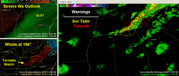
The NWS has extended the tornado watch down into extreme North Alabama this evening because of conditions that are favorable for tornadoes to develop over Lauderdale, Limestone, Madison and Jackson Counties. It will go until 10 p.m.
The main factor is strong mid level winds, running over 115 mph at 18,000 feet over Tennessee. There is also quite a bit of spin, or helicity, in the lower levels of the atmosphere over Tennessee, North Carolina and extreme northern Georgia and Alabama.
A line of intense thunderstorm extends from McMinnville to Tullahoma to Fayetteville in Tennessee then onto the northwest corner of Alabama near Lexington.
Severe thunderstorm warnings are in effect for Limestone, Madison and Jackson counties.
The most dangerous storm is near Fayetteville TN and it has a tornado warning with it. It may impact extreme northern Jackson County around Pleasant Grove and Bridgeport.
The line is moving east southeast at 40 mph.
The activity is expected to weaken to showers gradually as we go through the evening. Areas from Marion and Winston Counties east and northeast are most likely to see storms through late evening before the storms weaken.
A dry line has pushed into northwestern Mississippi and western Tennessee at this hour. A cold front is approaching Memphis. This front will push southeastward overnight, pushing the showers ahead of it. They will be southeast of Birmingham shortly after midnight.
Category: Alabama's Weather


