A Few Flurries Possible Tonight…
An all new edition of the ABC 33/40 Weather Xtreme video is available in the player on the right sidebar of the blog. You can subscribe to the Weather Xtreme video on iTunes by clicking here.
COLD AND ACTIVE: Much colder air is flowing into Alabama at mid-afternoon. Muscle Shoals and Haleyville have dropped into the upper 30s, and that colder air will spread over all of Alabama tonight. Support from the upper trough could squeeze out a few snow flurries this evening, perhaps as far south as Birmingham and Anniston, but they won’t amount to much. Everybody should be down in the mid 20s by daybreak tomorrow.
CALM DAY TOMORROW: Cool and dry… a partly sunny sky with a high in the low to mid 40s.
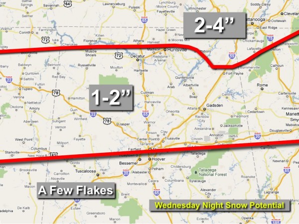
SNOW FOR WEDNESDAY NIGHT: Not much overall thinking on the snow event for North Alabama Wednesday night. Below is the first snow accumulation potential outlook…
Here is the situation…
*Snow should spread into Northwest Alabama Wednesday evening, becoming widespread by 9:00.
*The best chance of accumulating snow will be along and north of a line from Millport to Birmingham to Anniston. North of that line we are projecting average amounts of 1-2 inches, with pockets of 2-4 inch amounts across higher terrain of Northeast Alabama. Very much in line with the 12Z NAM.
*Snow flakes are possible as far south as Livingston, Brent, Clanton, Rockford, and Roanoke, but accumulation there is not likely.
*We will drop into the mid 20s Thursday morning as the snow ends (it should be over by 7:00 a.m.), so some icy travel is likely where there is accumulation early Thursday. We should warm into the upper 30s by late morning, so unless it is colder than we think, this should not be an all-day kind of issue with travel concerns.
*The coldest morning will be Friday morning, when the sky should be clear. Where snow is on the ground, lows in the teens are likely. Where there is no snow, lows will be in the 20-24 degree range.
WEEKEND WARM-UP: We are still looking at a wonderful weekend… after a low in the 20s early Saturday, we will warm to near 50 Saturday afternoon, followed by a high in the 57-60 degree range on Sunday. Dry air should mean a good supply of sunshine both days.
LONG RANGE: No doubt there will be cold snaps during the latter half of February, but with no big upper ridge over the western part of North America tapping Arctic air, it still looks like the second half of February will be milder than the first half. We can see that light at the end of this long, cold winter tunnel.
WEATHER BRAINS: Don’t forget you can listen to our weekly 30 minute netcast anytime on the web, or on iTunes. This is the show all about weather featuring many familiar voices, including our meteorologists here at ABC 33/40. We will record this week’s show tonight at 8:30 p.m. CST…
FOLLOW ALONG: Here are our weather team Twitter accounts….
| James Spann | Jason Simpson | Ashley Brand |
| J. B. Elliott | Bill Murray | Brian Peters |
| Dr. Tim Coleman | WeatherBrains Podcast | E-Warn (AL wx watches/warnings) |
Look for the next Weather Xtreme video here by 7:00 a.m. tomorrow…..
Category: Alabama's Weather


