T-Minus 30 Hours
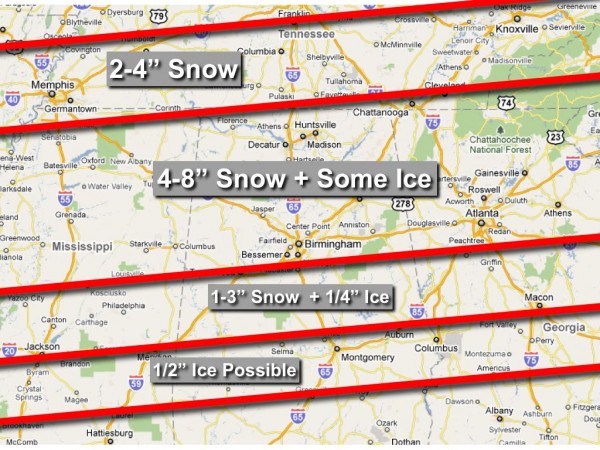
Writing this late Saturday morning, about 30 hours prior to the expected beginning of a significant winter storm for Alabama.
You can scroll down for a look at our forecast and projections… but we are just about at that time when we quit flying with instruments (computer model output), and begin to fly visual (look at actual observed data). Sure, there will be many more runs between now and tomorrow (the RPM runs every three hours), but don’t expect much change in the forecast this afternoon or tonight. You can read J.B.’s post below this one about the surface low now being on the board. Here are some points about what we know, and what we don’t know…
*Confidence is very high that there will be a significant amount of snow across parts of North or Central Alabama.
*Confidence is high in that some freezing rain will be involved in a zone across Central, or maybe even South Alabama.
*Confidence is high that the most intense part of this storm will be from about 8:00 p.m. tomorrow through 8:00 a.m. Monday.
Now, this is what we struggle with…
*Placement of the heaviest snow band. With systems like this, a deformation axis will usually become established. This is an area in the atmosphere where winds converge along one axis and diverge along another. Lifting is enhanced, and you get heavy snow. This band is usually 30-50 miles wide, and that is where we fully expect some 8 inch totals. This band could be anywhere from Birmingham and I-20 to Huntsville, along U.S. 72. Away from that heavy snow axis, snow amounts of 4 inches are likely 30 miles on their side, and away from there the amounts will greatly drop off.
*Placement of the axis of heavy freezing rain. This is the biggest issue, since a long period of freezing rain will bring an “ice storm”. Freezing rain is simply rain that falls in liquid form, and then freezes on impact with surface temperatures at or below 32 degrees. If there is enough ice, then trees and power lines can come down, and we get into a big mess. Seems like the best bet for this will be roughly along U.S. 80, but it could be a little farther to the north, impacting places like Greensboro, Clanton, and Ashland.
And, these two points are true with every Alabama winter storm…
*Some will be delighted with the amount of snow they see, and others severely disappointed.
*There will be surprises.
We all know that snow and ice don’t follow those nice, straight lines we draw on the maps (like our forecast below). These maps give a simple visual guideline of what we expect based on what we know now. The next changes in this map will be based on actual observed upper air and surface data, with a much smaller consideration from model guidance.
Category: Alabama's Weather, Met 101/Weather History


