Friday Night Notes
Just some random information as things have finally gone somewhat calm for a bit….
*Deep down inside, the anticipation of snow brings back the excitement I remember as a child. I saw my first snow flakes at the old Normandale Mall in Montgomery when I was in first grade (I was living in Greenville at the time). They weren’t very big, and the snow didn’t accumulate, but man was that too cool.
*Many have asked about this storm and how it compares to the Blizzard of 1993 (March 13-14, 1993). No comparison at all. The 1993 storm featured convective snow (thunder and lightning), hurricane force wind gusts on ridges, and a rapidly deepening low in the Gulf of Mexico, with pressure falls much like a hurricane. The surface low driving the Sunday/Monday event is not as strong, and will actually weaken as it lifts northeast Monday.
*This is the first major winter storm we are dealing with since the widespread adoption of “social media”. It has been wonderful today being able to push weather tidbits out to those on Facebook and Twitter. I have 34,700 followers on Facebook, and 14,200 followers on Twitter, so that is quite an engaged audience that can be reached in a heartbeat. Of course, you can only post small nuggets of information via social media; the blog here will always be our workhorse with the serious detailed information. I also love the two-way conversation that social media offers.
*A big atta-boy to Bill Murray and Trey Nolen, who wrested with the beast of record blog traffic this morning. We were all getting very frustrated with blog outages and slow response, but they added capacity this morning along with a little other bits of magic, and now we are chugging along smoothly. I hope to never see the “high traffic” mode again.
*Forecast confidence is actually high on the impact of this winter storm; the difficult issue remains dealing with the possibility of freezing rain somewhere over Central, or maybe even South Alabama Sunday night. I have fear somebody in Alabama will have enough ice for some power outages, but we just don’t have the skill to nail it down at this phase of the game.
*Prior to any weather event, funny how we get people asking us why they hear different forecasts at other places from other sources. As I have stated here before, we really don’t have much interest in what a TV station, cable channel, blog, Sponge Bob, Bullwinkle, or Country Boy Eddie says… we simply don’t have time to think about it. We do our best to show you why we forecast what we do here with the videos and detailed discussions. You will have to ask the other guys about their forecast.
*Gonna be fun working with John Oldshue again… as you know he is covering for Ashley Brand while she is away on maternity leave. I will be going the Sunday evening weathercasts in the studio, while John will be out in the field chasing those snow flakes. We worked many long hours together from 1997-2006.
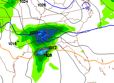
*Hey… the new 00Z NAM is in, and boy does it look snowy for the I-20 corridor late Sunday night. The map below is valid at midnight Sunday night…
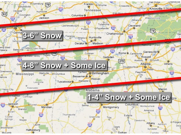
Looks like our ongoing forecast below is in great shape. We will keep the blog freshly updated all weekend. Stay tuned…
Category: Alabama's Weather, Winter Weather


