Severe weather update – 1155 pm
…TORNADO WARNING PICKENS AND LAMAR COUNTIES UNTIL 1230…

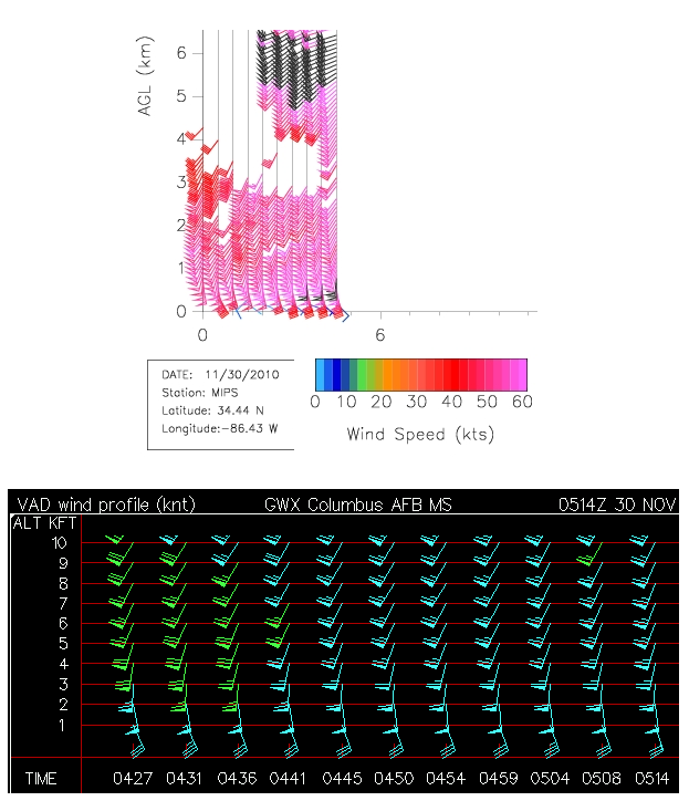
The above graphic shows the radar-derived VAD wind profiles (or winds as they vary with height). Notice how the winds are out of the SE at 30 knots at 1,000 feet, then curve around to be out of the SW at 75 knots at 5,000 ft. This is tremendous wind shear and helicity, causing rotation to be likely in any storm that forms.
Another concern is gravity waves. In this high-shear environment, we are seeing possible waves on radar flying NE at speeds around 60 knots, possibly interacting with storms and making them more likely to produce a tornado.
Finally, the sharp gradient in temperature and dewpoint across Alabama is a concern, too. It is 67/62 at TCL, but 50/48 at GAD. Strong gradients along warm fronts like this add additional rotation to storms.

As the storms move in from the west, be ready. With this much wind shear, it doesn’t take much of a storm to produce a tornado. There have been 2-3 tornadoes in Mississippi already, one of them in north-central MS (causing injuries).
Please keep a NOAA Weather Radio on or get up and check the weather around 230 am in the BHM area, and earlier over west Alabama. Have a plan ready to go at a moment’s notice as to where you will go. If a tornado warning is issued, leave mobile homes for any building.
Category: Uncategorized
About the Author (Author Profile)
Subscribe
If you enjoyed this article, subscribe to receive more just like it.


