Long Night Ahead
It’s going to be a long night across North and Central Alabama tonight as a strong storm system pushes into the state.
A warm front has surged northward to nearly Tupelo in northeastern Mississippi. It extends back southeastward to near Marion, Selma and Troy. South of that front, dewpoints are in the middle and upper 60s, indicative of very moist air.
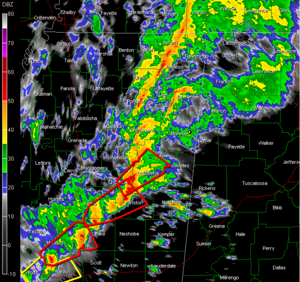
That warm moist air is combining with strong winds aloft to fuel a long line of intense thunderstorms from near Jackson TN into northern Mississippi. Further south, the most intense storms extend from near Ackerman to Canton to just west of Jackson in Mississippi then on back to near Port Gibson in southwestern Mississippi.
Two tornado warnings in Mississippi right now…one for the dangerous storm near Clinton, or just west of Jackson…the other for a dangerous storm passing just north of Carthage.
Make that three tornado warnings…a new one issued for areas from Ackerman to Starkville. That area has been under the gun for the past hour and a half with at least three supercells passing through there.
Earlier, we were tracking a very impressive storm near Kosciusko…and it turns out to have produced numerous injuries four miles SW of Kosciusko.
Severe thunderstorm warnings are strung out along the line all the way back into eastern Louisiana.
A tornado watch continues into the early morning hours for much of Central and southwestern Mississippi into Central Louisiana. It goes until 5 a.m.
Look for a tornado watch to be extended into Alabama within the next hour or so.
Severe storms should approach West Alabama’s Lamar County just after 11:30 p.m. and around midnight will be nearing Pickens County.
We will be up all night with you giving frequent nowcast updates and mesoscale analysis from Dr. Tim Coleman.
Category: Severe Weather


