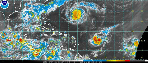
Late Night Look at the Tropics
TROPICAL TOTE BOARD: Five named storms so far in the North Atlantic basin this hurricane season. Two of them have become hurricanes; one has achieved major hurricane status.
DANIELLE: Major hurricane Danielle is about 350 miles southeast of Bermuda tonight Top winds are around 135 mph, meaning the storm is a category four hurricane. Tropical storm force winds extend out 150 miles to the northwest of the center. Danielle is already recurving to the north and northeast and the center will pass east of the island, keeping the worst weather to the east. Danielle will slowly weaken over the next 24 hours as it turns to the northeast.
FROM THE BERMUDA WEATHER SERVICE: The forecast… Winds and waves will continue increasing overnight as Danielle continues to move north. Saturday will have strong winds, gale force gusts, occasional showers, some heavy, and a chance of thunder as Danielle passes approximately 200nm to our east. Large swells will develop, especially along South Shore. Conditions begin to ease on Sunday.
EARL: The second of our current named storms is 800 miles east southeast of the Virgin Islands. Top winds are 50 mph. Earl is expected to become a hurricane by Sunday and a major hurricane next week. It appears that Earl will follow Danielle into the weakness that the first hurricane will be leaving, but it will pass within 100 miles of the Virgin Islands on Monday, so folks in the northern Leeward Islands are understandably nervous.
FIONA: A large percentage of the hurricanes that form in the eastern Atlantic recurve out to sea. But the more hurricanes that line up, the worse our odds become. Don’t look now, but the embryonic Fiona is likely to be classified as a tropical depression today over the eastern Atlantic. There is not a clear picture of what will happen to the eventual Fiona. It could quite possibly follow Danielle and Earl out to sea.
GASTON: The disturbance about 400 miles west southwest of the Cape Verde Islands will become a depression today and likely Tropical Storm Gaston shortly thereafter. With each new storm, the chance that the steering pattern will change and we will have to deal with a threat to the U.S.
DON’T LOOK NOW: But this train of disturbances off of Africa will continue for the next few weeks, and we will continue to see more hurricanes.
Category: Uncategorized


