Southeast tornado research at UAH
The posts written by Bill Murray and myself yesterday about “Dixie Alley” seem to have gotten some attention. You can see those here and here. These describe the possible reasons for the misconceptions about where tornado alley is, and the resulting bias in the research world over the past 30 years toward Plains tornadoes (Texas, Oklahoma, Kansas, Nebraska). We at The University of Alabama in Huntsville are trying to change that focus, at least somewhat, to help the NWS offices in the SE with the difficult task of issuing warnings in this part of the country.
We have people working on dual-polarimetric radar signatures (the next phase NEXRAD that will go nationwide in the next 4 years), forecasting lightning, and examining hurricane dynamics in the northern Gulf. Over the past few years, the group I work in has looked at a number of factors, external to the parent storm, that may influence tornado formation. Here are some basics on a few of those:
1. Topography
In the eastern US, the terrain is very rough in some areas, and Alabama is no exception. Terrain may affect tornadoes in two different ways.
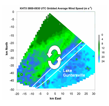
First of all, wind may be channeled in valleys between mountains. This causes the wind to blow parallel to the valley, and often increases the speed (like standing between two buildings). Here is the radar-analyzed average wind speed over NE Alabama on the early morning of Feb 6, 2008 (Super Tuesday outbreak).
The winds in the valley where Lake Guntersville is located are 10-15 mph faster than the winds in the mountains on either side. This creates spin in the atmosphere on the north side of the lake, possibly enhancing a spinning storm in that area. There are numerous locations like this around the SE.
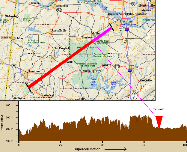
Another way terrain may influence tornadoes is through stretching. Angular momentum must be conserved. When an ice skater spins with their arms out, then pulls their arms in, making the radius smaller, they spin faster. With a tornado, we have noticed that damage is sometimes worse in a valley than on a ridge, contrary to what some think. This could be associated with the tornado becoming stretched as it goes over a valley, becoming taller and thinner, spinning faster. An example is the Lawrence County tornado from Feb 6, 2008. The storm moved through several counties on a plateau, producing little damage, then once it moved over the drop into the Tennessee River Valley, an EF-4 tornado formed quickly.
In the above map, the red shows the storm track before the tornado, and the purple shows the tornado track. A cross-section of the terrain along that line is also shown. Notice the tornado formed right after the storm went past the plateau and over lower ground.
2. Gravity waves
Here in the SE US, many tornado outbreaks occur in the cool season, with our secondary tornado season being November and December, and tornado season really starting again in late February. With high wind shear and low stability, waves in the atmosphere similar to water waves often form, called gravity waves. If you’ve noticed at the beach, as a wave approaches, the water rushes out towards the ridge, creating convergence. This convergence of fluid also may cause the spin in a storm to become taller and narrower, and spin faster when an atmospheric wave approaches. Waves also cause wind shear.
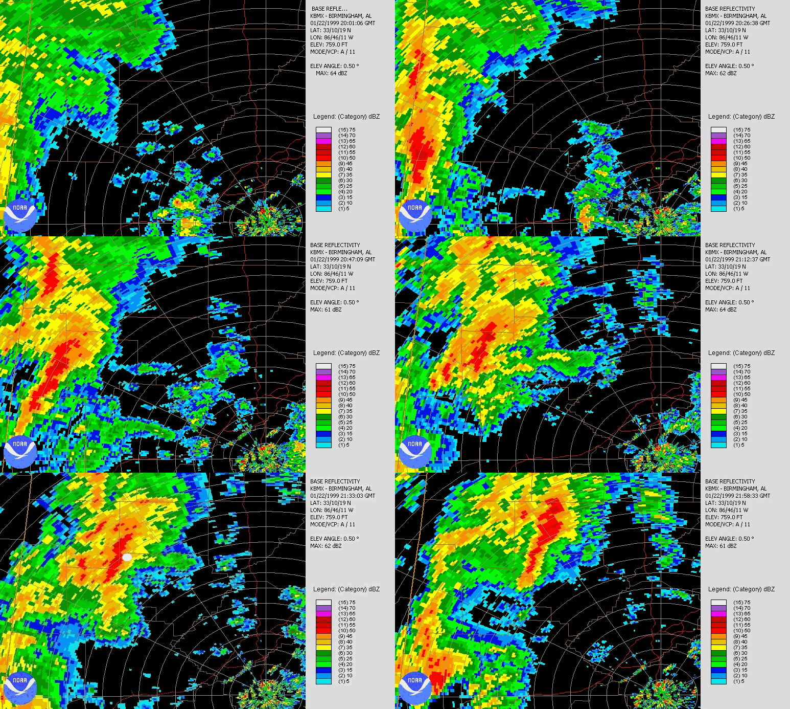
To understand all this, we developed two models, the more complicated one called GRiTs (GRavity wave Interaction with Tornadoes). The models show that when a wave interacts with a storm, the spin may increase and sometimes results in a tornado. The waves may show up on radar as fine lines, caused by the wave ridge lifting air and causing condensation. These waves often move 70 mph. Below is an example of two waves interacting with a storm in NW Alabama, possibly leading to a tornado in Fayette County in 1999.
We have analyzed and will continue to analyze numerous cases like this one from all over the US, but the ideal environment for waves and severe weather is high shear and low CAPE, like we get often here in Winter tornado outbreaks.
3. Friction
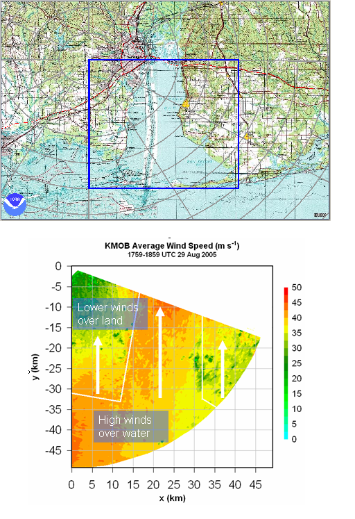
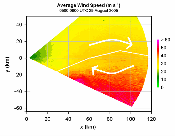
Friction slows the wind down. However, different types of land surface have more effect than others. Wind blows fastest over water, and slowest over rough terrain or cities with buildings. When areas with different friction are next to each other, such as along the coastline, near bays, or near lakes, spin may occur that can affect a storm and sometimes cause or prevent a tornado.
In the case below, the average winds over Mobile Bay once Hurricane Katrina had moved inland are shown. The winds are moving up to 20 mph faster over the water than over the land. This creates positive spin on the western shore (Mobile) and negative spin on the eastern shore (Baldwin).
Two different examples of this are shown during Hurricane Katrina along the MS coast, and Ivan on the FL coast. Ahead of Katrina, easterly winds were slowed down along the land, creating negative spin and causing rotating storms to weaken as they moved inland.
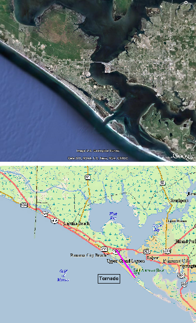
As Hurricane Ivan approached, Panama City Beach was located in a position with condos slowing the wind down along the beach, and water north of there over Grand Lagoon and West Bay. This *may* have been part of the reason a tornado formed at the east end of Panama City Beach, then moved across Grand Lagoon and Middle Beach Rd.
For more information and examples of these events, look at some of my presentations on gravity waves and tornadoes, terrain, and all external factors.
We still have a lot of work to do, not only figuring out how all of these factors are affecting tornadoes in the Southeastern United States, but also learning how to predict these effects and teach NWS and TV meteorologists how to look for them. In research, there’s almost always pressure to get funding, so if you know any rich Alabamians out there who want to help with our research, we’ll name an equation after their family!
Category: Met 101/Weather History


