Alabama Snow FAQ
I had a great time this morning at Centreville Middle School… those kids will be on the Pepsi KIDCAM today at 5:00 on ABC 33/40.
Let’s do a snow FAQ for you….
WHEN WILL IT BEGIN? Snow begins tonight over Southwest Alabama, spreading northeast during the night. Seems like the precipitation is ahead of schedule, and snow could begin in Tuscaloosa and Birmingham well before daybreak tomorrow. Snow should arrive in Anniston by 6:00 to 7:00 a.m.
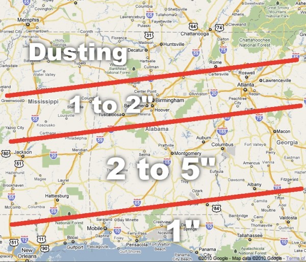
DRIVING PROBLEMS? The heaviest snow should be over South-Central Alabama (see our map below), but there could be enough snow in Birmingham, Tuscaloosa, and Anniston for some slick spots. And, with the precipitation possibly coming in very early tomorrow morning, temperatures could be at or just below freezing initially, meaning some icy spots on bridges. Get up extra early tomorrow morning to check on road conditions…
Travel will be very difficult during the day over the southern half of the state, where snow amounts of 2 to 5 inches are likely, with isolated heavier amounts. Some driving difficulties are possible deep into South Alabama during the day tomorrow.
HOW MUCH? Again, see the map below. Remember, snow won’t accumulate exactly along the lines I have drawn, but this is a guideline for emergency managers and others that must make plans for tomorrow. And, that map could change again before the event begins as we “look out the window” and study ongoing weather to the west this afternoon.
ANY ICE? The atmosphere will be very cold, and it will be all snow for much of Alabama, north of U.S. 84. Some rain and sleet could mix in over far South Alabama as warm air advection kicks in. But, around here we are talking snow and not freezing rain or ice accumulation.
POWER OUTAGES? We don’t expect any issues over North-Central Alabama, but quite frankly there is some chance the snow could be heavy enough over South Alabama for isolated issues down there where a few spots could see 6 inches. But, remember, this is snow and not ice, so major power outages are not expected.
SHUTTLESWORTH AIRPORT: There could be some delays at Birmingham-Shuttlesworth International Airport, and major delays are possible at Hartsfield Airport in Atlanta with snow in the Atlanta metro tomorrow. And, of course, the Northeast U.S. Airports are still playing catch-up, so if you are flying tomorrow, plan on being very patient!
The NWS will be issuing a winter storm warning soon for parts of Central and South Alabama… that will be posted as soon as it is issued.
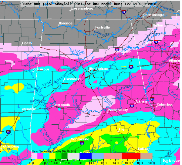
The 12Z NAM snow accumulation is below, which matches up nicely with our snow accumulation which is below that.
LIVE CHAT: We are now offering a real time chat here on the blog… open blog comments will stay in place, of course, but this will allow a more immediate method of communication for weather geeks. We do have moderators posted over there, so be sure and play nice. Members of our weather team will be there from time to time to answer questions; we will post those times we are available here on the blog.
Category: Uncategorized


