Remembering Tropical Storm Allison (2001)
On June 5, 2001, ship, buoy and recon reports indicated that a tropical storm had formed in the Gulf about 80 miles south of Galveston. It had top winds of 60 mph. Twelve hours later, it made landfall near the west end of Galveston with 50 mph winds. 8-12 inches of rain fell across Galveston and Harris Counties that night. The storm drifted north to near Lufkin on the 6th. The storm was being steered northward slowly by the subtropical high over Florida. That high weakened and the steering currents collapsed. The center of the remnants of the storm described a loop. An additional 8-12 inches of rain fell across parts of Harris County. On Friday the 8th, the system was moving south again. More heavy rain fell across the Houston area that morning, but skies cleared by lunch and as sun heated the atmosphere, it was evident that there were going to be problems.
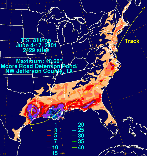
Thunderstorms formed during the afternoon, fueled by a strong inflow on the eastern side of the circulation of the remnant low. The storms merged into a huge complex over the city of Houston. Flash flooding began during rush hour. By late evening, every major road and interstate in Houston was underwater. The University of Texas hospitals were being inundated. Torrential rains fell for over 10 hours across the city. Rainfall rates averaged four inches per hour in spots. Twenty inches of rain fell in Green’s Bayou. 35-40 inches of rain fell in Northwest Jefferson County. 36.99 inches was reported at the Port of Houston. Houston’s six day total was 38.6 inches. When all was said and down, 30,000 people were left homeless in the Houston area. 73,000 homes were flooded. 95,000 vehicles were destroyed. A total of 99 flash flood warnings were issued by the National Weather Service in Houston.
Here is an example of a dramatic flash flood warning from the NWS Houston.
WGUS54 KHGX 090800
FFWHOU
TXC201-091345-
BULLETIN – EAS ACTIVATION REQUESTED
FLASH FLOOD WARNING
NATIONAL WEATHER SERVICE HOUSTON/GALVESTON TX
250 AM CDT SAT JUN 9 2001
THE NATIONAL WEATHER SERVICE HAS ISSUED A
* FLASH FLOOD WARNING FOR…
HARRIS COUNTY IN SOUTHEAST TEXAS
* UNTIL 845 AM CDT
* THIS IS A VERY DANGEROUS FLOOD SITUATION! MAJOR ROAD FLOODING IS
OCCURRING OVER MOST OF THE HOUSTON METROPOLITAN AREA. MANY MAJOR
ROADWAYS ARE NOW IMPASSABLE AND TRAVEL SHOULD NOT BE ATTEMPTED
EXCEPT FOR EVACUATION PURPOSES. AT 243 AM CDT…DOPPLER RADAR
INDICATED THAT VERY HEAVY RAINFALL CONTINUED OVER MOST OF HARRIS
COUNTY. BETWEEN MIDNIGHT AND 3 AM… 7 TO 9 INCHES OF RAIN FELL
BETWEEN JERSEY VILLAGE AND ALDINE AND BETWEEN BEL AIR AND DOWNTOWN
HOUSTON. BETWEEN ALDINE AND CROSBY… 8 TO 10 INCHES FELL IN THE
SAME 3 HOUR PERIOD. STORMS PRODUCING 3 TO 4 INCHES OF RAIN PER HOUR
WERE MOVING NORTHEASTWARD FROM BETWEEN DEER PARK AND CHANNEL VIEW AT
245 AM. AN ADDITIONAL 5 TO 8 INCHES OF RAIN MAY FALL OVER THE
COUNTY PRIOR TO 9 AM… AND EVEN THOUGH PRECIPITATION IS EXPECTED TO
DIMINISH IN INTENSITY PRIOR THAT TIME… FLOODING WILL STILL BE
WIDESPREAD DUE TO THE COPIOUS RAINS OF THE PAST 10 HOURS.
* FLOODING IS EXPECTED IN OR NEAR…
ALDINE…BELLAIRE…BUNKER HILL VILLAGE…CHANNELVIEW
DO NOT CROSS ANY LOCATION WHERE WATER COVERS THE ROAD!
PLEASE REPORT FLOODING TO THE COUNTY SHERIFF…LOCAL POLICE…OR
DEPARTMENT OF PUBLIC SAFETY. THEY WILL RELAY YOUR REPORT TO THE
NATIONAL WEATHER SERVICE.
LAT…LON 3004 9513 2961 9506 2955 9512 2963 9542
2978 9576 3009 9590
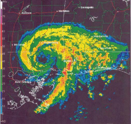
But Allison was not finished. The center drifted back into the Gulf of Mexico, just 22 miles west of where it had originally made landfall. The system developed subtropical characteristics after moving back over water. It turned east and headed toward Louisiana, making landfall on the 11th. It actually intensified over land and became a subtropical storm. Winds increased to 45 mph and the system actually developed an eye feature. A total of 29.86 inches of rain fell in Thibodeaux, causing more incredible flooding.

The system moved across Mississippi and Alabama, dumping up to ten inches of rain in spots. Five people drowned in rip currents off the Northwest Florida coast. Allison’s remnants eventually stalled over North Carolina after producing severe weather in Georgia. It finally moved out to sea on the 17th, where is briefly re-attained subtropical storm status.

Damage totaled $5.5 billion, making Allison the most costly tropical storm in history. Allison is the only tropical storm to have its name retired. A total of 41 people were killed.
Category: Uncategorized


