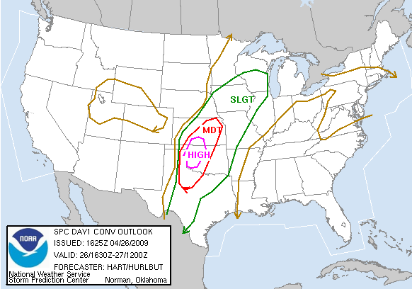
Severe Weather Outbreak Today over Plains States
It’s going to be an active severe weather day over a wide area from Texas to Wisconsin.
The SPC has a high risk for severe weather over southern Kansas and western Oklahoma. A moderate risk area extends from eastern Kansas into northern Texas.

Watches are in place across the Plains. The red boxes are tornado watches. The blue ones are severe thunderstorm watches. The southernmost two watches are PDS (particularly dangerous situation) watches.
a few severe thunderstorm warnings are in effect now across northwestern Oklahoma, but this is just the opening act for the main event. Instabilities are increasing over the Texas Panhandle and western Oklahoma behind this main line. Shear will also be increasing as an upper disturbance swings out of New Mexico. Helicities will be very high late this afternoon into this evening. Intense supercells will be the rule with an enhanced risk of severe weather, including a widespread risk for tornadoes.
National Weather Service Norman Severe Weather Nowcast Page
Across Alabama…the radar is clear, skies are partly cloudy with mainly high clouds noted, winds are out of the south and southeast, temperatures are in the lower and middle 80s and dewpoints are in the middle 50s. The morning run of the GFS keeps us dry until late Thursday, but brings the system through Alabama Thursday night and Friday morning. But it has been flip flopping a bunch lately. Gonna be a tough forecast toward the end of the week. A bigger storm still looks possible for late Sunday into Monday.
Category: Uncategorized


