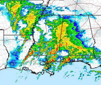
Severe weather analysis
Still a complex weather situation, making for a difficult forecast. Large area of rain and storms moving northeast out of south MS and AL toward BHM. It looks like the warm front has made it just north of BHM, where the wind shift line is. However, the high dewpoint (>60) air is still lagging south of MGM and TCL.
The models are having a hard time. When you consider they predict only 0.25″ of rain along I-20 before 7 am, and you look at the above radar, maybe they’re not handling it well. Despite the low instability, the rain and storms moving in from the SW will still pose a small threat for tornadoes overnight, so have your weather radio on standby if you go to bed (that’s what I’m doing). But, it still looks like the most significant tornado threat here will come during the daytime hours tomorrow, as the more moist air comes in, and wind shear increases.
Be careful everyone! Have a tornado plan ready wherever you are tomorrow.
Category: Uncategorized


