Notes from the Hurricane Zone…
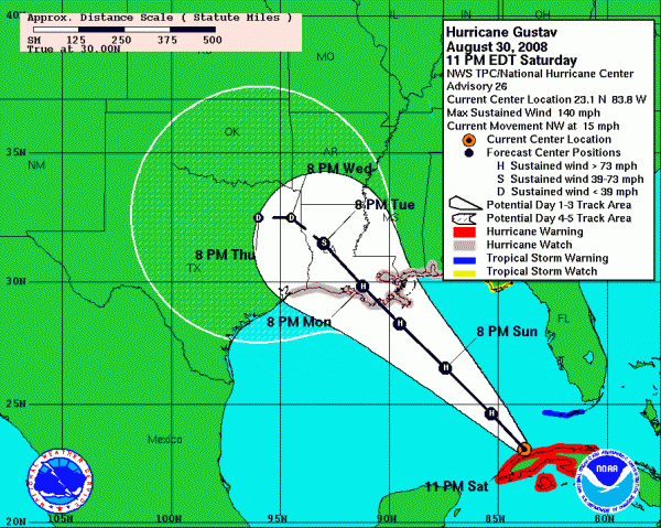
Just three years after Hurricane Katrina, Southeast Louisiana is facing an existential situation. Another major hurricane is bearing down on the vulnerable region, this time from a different direction and potentially threatening different areas than before, as well as some of the same areas.
Landfall is expected to come Monday afternoon over southern Louisiana. The models are trending slightly to the east, further increasing the threat to New Orleans. But the devastating effects of Gustav are going to be widespread.
Storm surge flooding will be the most serious concern. The circulation around the large and powerful storm will drive huge quantities of water into the funnel between the Mississippi River and the Mississippi Coast. Storm surge heights may reach 15-20 feet in places like New Orleans East, Slidell and low lying St. Bernard Parish. Along the Mississippi Coast, they will reach ten feet or higher. In Alabama, they could reach 4-6 feet above sea level.
Winds will rise to tropical storm force during the pre-dawn hours on Monday over the southern Parishes of Louisiana, reaching New Orleans around daybreak. Strong tropical storm force winds of 58 mph or high will arrive around midmorning and overspread the area. Winds of 120-150 mph will cause catastrophic destruction across parishes like Terrebonne, Lafourche, Assumption, Iberia and St. Mary. Hurricane force winds will cause widespread damage along a 100 mile wide swath all the way to Central Louisiana. Tropical storm force winds will be felt as far east as the Alabama coast and as far north as Arkansas.
Flooding from rainfall will be a huge issue, especially if the storm slows over northern Louisiana and Northeast Texas. Rainfall totals will exceed 15 inches over a wide area. Amounts of 6-9 inches may extend into Northeast Texas.
Tornadoes will be a problem to the east of the track, extending over as far as Southwest Alabama on Monday.
We do not expect any significant problems in Central Alabama, although there will be feeder bands with storms and even isolated tornadoes possible on Monday and Tuesday. It will also get slightly breezy, but only 10-20 mph at the most, which is not enough to cause damage.
I used to love listening to WWL on the radio when a hurricane was threatening South Louisiana. At night, you could pick up their signal clearly. Now, you can hear that signal clearly day or night, thanks to Al Gore. But what I am hearing, I am not liking. Three years ago, we watched as New Orleans became a third world country in the wake of Katrina. Preparations so far for Gustav appear to have been masterful.
I just hope Mother Nature doesn’t trump her previous performance.
Category: Uncategorized


