Late Morning Tropical Thoughts
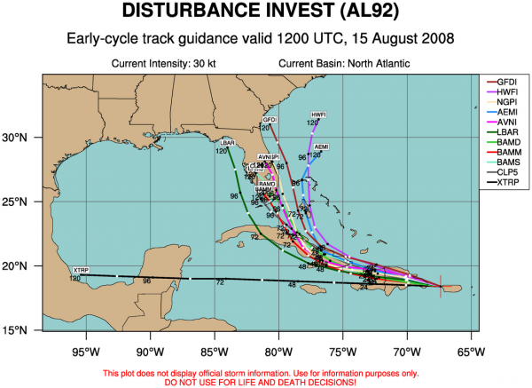
Lots of buzz about the 12Z model set shifting west:
Just a few quick notes…
*The models are having a hard time initializing this tropical wave since there have been multiple centers in the last two days. Good initialization won’t happen until this really consolidates and gets it act together.
*I think the ultimate center will hug the northern coast of Hispanolia. The mountains will disrupt the circulation and prevent this from growing into something significant in the short term.
*The 12Z GFS is running, and wants to bring Fay toward the Florida Keys, with the northward turn into the Florida peninsula.
*The 12Z NAM keeps the system about 100 to 150 miles east of the Florida coast in the open water of the Atlantic.
I think it is simply too early to get worked up over any one specific solution… we need to get this organized first. The great Alabama weather legend, J.B. Elliott, called for a Carolina landfall on WeatherBrains, and I think he is on to something. But even great weather legends are making educated guesses at this point. Smooth out all tropical tracks going back to 1850 in August with a similar upper air pattern and ENSO stage and you have to like the idea of the greatest risk being on the Atlantic coast.
Everyone from Key West to Cape Cod will need to watch this; I still believe the odds of this getting into the Gulf of Mexico are small. But, this thing is going to go where it wants, no matter what anybody writes on a weather blog or says on television. To me, this is what makes this business so interesting. More on the afternoon discussion later today by 3:30…. along with a fresh Weather Xtreme video.
Category: Uncategorized


