More Snow For Parts Of Alabama
An all new edition of the ABC 33/40 Weather Xtreme video is available in the player on the right sidebar of the blog. You can subscribe to the Weather Xtreme video on iTunes by clicking here.
THIS AFTERNOON: Lots of sun, but cold. Cullman and Decatur are only in the upper 30s at 2:00… most other locations around I-20/59 are in the low to mid 40s, near forecast levels.
HERE WE GO AGAIN: Let’s go to the FAQ format again this afternoon as we approach yet another snow event for Alabama in this wild winter of 2010-11…
WHEN? Snow could begin over the northwest corner of Alabama as early as mid-afternoon… with the snow possibly reaching Tuscaloosa and Birmingham as early as 5:00. The snow will arrive in the Anniston/Gadsden area by 6:00-7:00. I should note that the precipitation could begin in the form of rain for places like Tuscaloosa and Birmingham, but it will change to snow rather quickly after dark. The heaviest snow with this event will come from about 6:00 p.m. tomorrow until 2:00 a.m. Thursday. Lingering flurries are possible through daybreak Thursday, but the event will be pretty much over by the time the sun comes up.
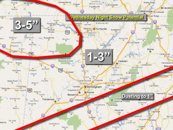
WHO AND HOW MUCH? We still believe the heaviest snow will be north of I-20… the northwest part of the state seems to be in a position to get the heaviest snow, where the dynamics are more favorable. Places like Florence and Russellville could see 3-5 inches. To the south, amounts will be mostly in the 1-2 inch range, although a few spots could see 3 inches. If you are in Birmingham, Anniston, Gadsden, or Tuscaloosa, 1-2 inches are possible in all of these cities. An inch is possible as far south as Eutaw, Calera, Munford, and Heflin. A dusting is possible as far south as Butler, Selma, Prattville, Dadeville, and Lafayette.
TRAVEL ISSUES? Temperatures will go below freezing tomorrow night, and travel could become a little challenging, especially in areas where a few inches of snow are on the ground. Initially, the roads will be just wet, and we do not expect any issues tomorrow afternoon. Surface temperatures will be below freezing generally in the 10:00 p.m. to 9:00 a.m. time frame. School delays are very possible Thursday morning where snow accumulated.
POWER PROBLEMS? Don’t expect any since no freezing rain is involved. There could be a zone with a mix of sleet, rain, and snow, but again ice accumulation won’t be a problem this time.
THE DAY THURSDAY: The sun should break out pretty early in the day Thursday, and we will be above freezing by 9:00 a.m., so the travel issues won’t be a long term issue. We should be close to 40 degrees Thursday afternoon with a partly sunny sky.
THE MAP: You know the deal… snow doesn’t magically follow these red lines… this map is simply a guideline. There will be surprises and exceptions. I changed the 1-2 inch zone to 1-3 simply because I do believe there could be a sweet spot where some 3 inches totals are possible, most most places will be in the 1-2 inch range. This is not what I would call a major winter storm, certainly nothing like some of the other ones we have dealt with this season.
FRIDAY AND THE WEEKEND: Where snow is on the ground, lows early Friday could be in the teens, but most places will see a low in the low 20s. Then, a warming trend kicks in Friday afternoon with a high in the upper 40s. The weekend looks much better, with lots of sunshine and a high in the low 50s Saturday, followed by a high not too far from 60 on Sunday.
NEXT WEEK AND BEYOND: Still looks generally mild for much of the latter half of February. I sure get the feeling the worst of the winter is behind us, but remember we have had decent snow events in April before. For much of next week it looks like we will enjoy highs in the low 60s.
WEATHER BRAINS: Don’t forget you can listen to our weekly 30 minute netcast anytime on the web, or on iTunes. This is the show all about weather featuring many familiar voices, including our meteorologists here at ABC 33/40. Scroll down for the show notes on this week’s new episode.
FOLLOW ALONG: Here are our weather team Twitter accounts….
| James Spann | Jason Simpson | Ashley Brand |
| J. B. Elliott | Bill Murray | Brian Peters |
| Dr. Tim Coleman | WeatherBrains Podcast | E-Warn (AL wx watches/warnings) |
Look for the next Weather Xtreme video here by 7:00 a.m. tomorrow…
Category: Alabama's Weather


