Very strong cold front
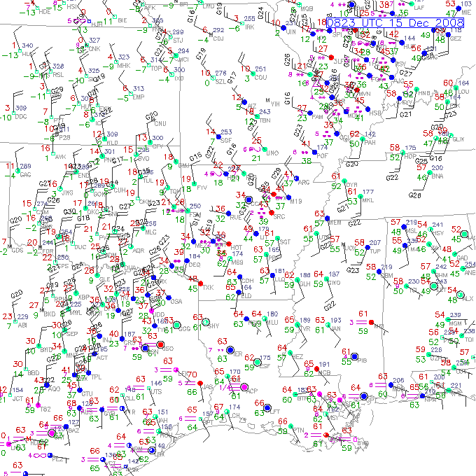
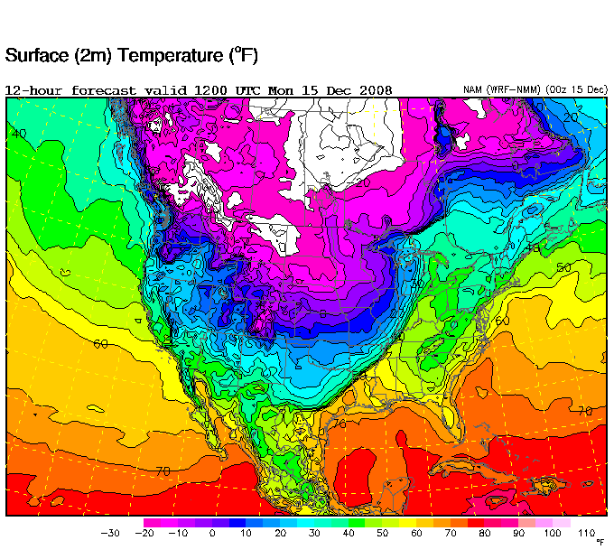
To our NW this morning, some spots are having a rapid drop in temperature. How about Fort Leonard Wood, MO, where it dropped from 56 degrees at 6 pm to 39 at 7 pm, and 17 at 3 am, with wind chills near zero? The Arctic air that has been sitting over Canada is moving southward through the central U.S. this morning, very slowly. Take a look at the surface map centered in Little Rock at 2 am, and the NAM model temperature map for the U.S. at 6 am (click on the maps to see them more clearly).
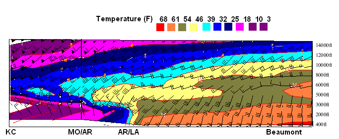
On the surface map, the red numbers are the temperatures. Notice the lower 60s ahead of the front in Memphis, but teens behind it in Oklahoma! Also notice the strong wind flags out of the NW behind the front, from Tyler, TX to southern Illinois. This is the really cold air we’ve been watching for at least 2 weeks now. Cold air is more dense than warm air, so it causes very high pressure at the surface (like the 31.00″ JB describes below), and it tends to spread out like water poured on a table, in what is called a “density current”. Cold air like this is typically rather shallow, as it is caused to a great extent by radiation from the snow-covered ground to our north, and the heavy, cold air stays near the ground. Look at the north-south cross section through the front, from near Kansas City to Beaumont, TX and on into the Gulf (sorry about the graphics, I had to color the temps by hand).
Notice the cold air is shallow near the ground. In Arkansas, it is 18-25 at the surface , but 46-54 degrees at 5000 feet.
Will this cold air make it to Alabama? Right now, the computer models indicate that it won’t anytime soon. A low pressure area has formed on the Arctic front in the Great Lakes area, and a ridge of high pressure is over the Atlantic. Southerly winds ahead of the front are holding it back, and bringing unseasonably warm air into Alabama. Highs should reach the 60s across most of Alabama today and tomorrow, with daytime temperatures in the 20s as close as Memphis. These computer models have a lot of physics in them, but I’m not sure they know how to handle extremely shallow Arctic air like this. With the warm air aloft, parts of west Tennesee and northern Arkansas are expecting a significant ice storm. The cold air could ease a little farther south, maybe as far as Muscle Shoals, tonight. But, it should retreat some by late week, leaving Alabama mainly in the warm air.
Models show the ridge weakening and moving southeast by next weekend, allowing the cold air to surge into Alabama. We’ll see. It’s still a week away, but if the cold air does come south, it could also bring some snow or ice in here. Nothing to change plans over at this time, just something to check.
Category: Uncategorized


Comments (1)
Trackback URL | Comments RSS Feed
Sites That Link to this Post