Things Calming (Fingers Crossed)
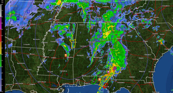
Our strong surface low has deepened to 993 mph tonight and it centered near Corinth MS. The cold front trails southward to just east of Jackson.
A couple of disturbances are rotating around the circulation over Mississippi with strong vorticity forcing thunderstorms. One segment is approaching Columbus MS and will move into Lamar and Pickens Counties by 11:45 p.m. There is a severe thundersorom warning for Lowndes and Noxubee Counties, but the storms have weakened. It remains to be seen if a warning will be required in Alabama, but it is looking more doubtful.
The warning that was in effect for Newton and Neshoba Counties in eastern Mississippi have been allowed to expire.
The NWS in Birmingham reports that it will allow the tornado watch to expire for Central Alabama at midnight.
Showers and some thunder cover much of Central Alabama east of I-65. Nothing severe there at this time. There is a little bit of instability in this area with a huge amount of shear, but the activity seems to be winding down.
Wind advisories continue through the overnight. Winds are still strong, averaging 12-25 mph with gusts to near 35 mph. Winds gusted to 36 mph last hour at Auburn and 31 mph at Gadsden.
The Flash flood watch was canceled a short time ago.
There is some damage in the Dothan area from a tornado that occurred about 30 minutes ago.
Search and rescue operations continue in the northeastern part of Pensacola where a significant tornado damaged an area near the Scenic Highway and I-10. Three buildings of an apartment complex were flattered. Teams with dogs are continuing to work late tonight. No reports of fatalities yet, which is great news.
Category: Alabama's Weather, Severe Weather


