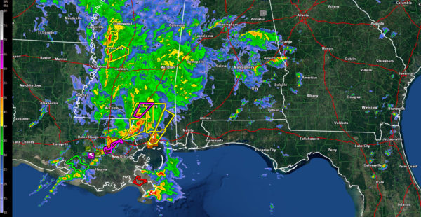
Showers and Storms Increasing Across Central Alabama
Heavy showers are increasing in the I-20 Corridor this afternoon across parts of Pickens, Sumter, Greene, Tuscaloosa and Jefferson Counties.
They are also heavy across southern Talladega, Clay and Randolph Counties.
All of this activity is growing upscale and will become thunderstorms soon.
Lightning just started occurring with the activity in extreme eastern Tuscaloosa and western Jefferson County. This activity is west of Rock Creek now.
The strongest storms in the state right now are approaching I-85 in the Auburn area. They are not severe at this time, but do have a lot of instability to work with (approaching 1,500 joules/kg).
Moderate to heavy rain covers much of West Central Alabama’s Pickens, Sumter, Greene, Hale and Choctaw Counties.
Flash flood watch remains in effect through tomorrow afternoon for Central Alabama and an Areal Flood Watch is in effect for the Tennessee Valley.
Wind advisories are in effect as well for all of Alabama except for the southeastern corner. Winds will gust in excess of 35 mph overnight as a strong surface low rapidly intensifies as it moves to a location just east of Memphis by midnight. The pressure is down to less than 996 mb.
In Mississippi, confirmed tornadoes are located southwest of Poplarville and southwest of Hattiesburg. Another dangerous tornado is near LaPlace, and will be cross the areas between Lake Mairepas and Lake Ponchartrain northwest of New Orleans. This storm has a tornado debris signature and is approaching I-55.
Multiple tornado watches are in effect to our southwest, including a PDS (particularly dangerous situation) tornado watch for southeastern Louisiana, southern Mississippi, southwestern Alabama and extreme western Northwest Florida including the Pensacola area.
Category: Alabama's Weather, Severe Weather


