Severe Weather Tomorrow Night
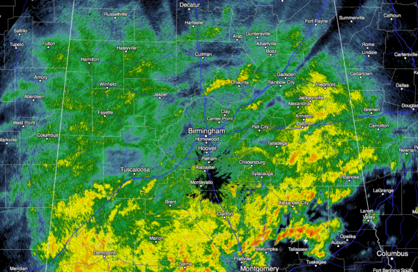
WET MONDAY: Rain is pretty widespread across North and Central Alabama this afternoon;temperatures are in the upper 50s and low 60s; they have changed very little since early this morning.
SEVERE WEATHER THREAT AHEAD: Tomorrow will be mostly cloudy and mild with showers during the day, but strong to severe storms arrive tomorrow night ahead of a deepening surface low that will move from north of Houston to a point between Memphis and Nashville. The surface low is supported by a deep upper trough, and the dynamics are quite favorable for severe storms. Bulk shear values (0-6 km) nearing 100 knots, a low level jet (5,000 feet) over 60 knots, and a steep lapse rate.
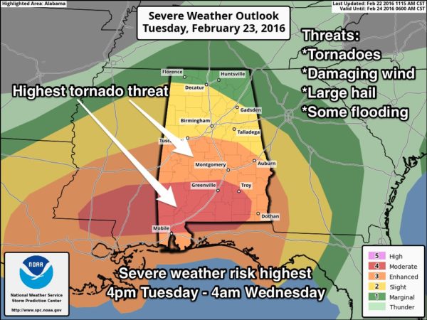
As usual, the thermodynamics are somewhat questionable. Highest instability values will be over the southern half of the state, where SPC has upgraded their outlook to include a “moderate risk” of severe storms for places like Troy, Greenville, Evergreen, Monroeville, and Grove Hill. An “enhanced risk” is now as far north as Tuscaloosa, Alabaster, and Lake Martin. The standard “slight risk” runs to Decatur and Boaz.
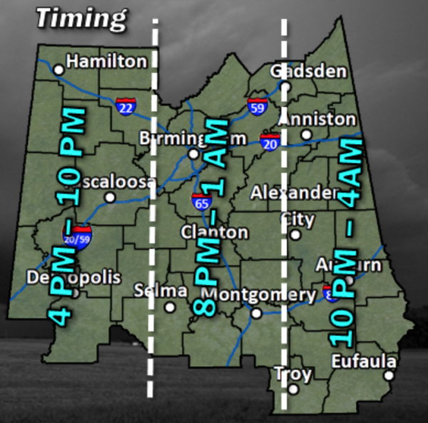
TIMING: We have indicated the main window for severe storms from 4:00 p.m. tomorrow through 4:00 a.m. Wednesday, but I really believe the core threat for most communities will come after 6:00 p.m. tomorrow. Storms become severe initially over West Alabama, with the risk moving eastward through the night.
PLACEMENT: Highest tornado threat will be along and south of I-20 (a line from Tuscaloosa to Birmingham to Anniston)… generally in the enhanced/moderate severe weather threat zone. But, an isolated tornado can’t be ruled out north of I-20 with very high bulk shear values.
MODES: In addition to tornadoes, storms tomorrow night will be capable of producing damaging straight line winds and large hail.
RAIN: Amounts of 2-3 inches are likely, and flooding is very possible in spots by tomorrow night. Especially the usual flood prone areas.
CALL TO ACTION: Since the severe weather threat will linger well into tomorrow night, be sure you have a properly programmed NOAA Weather Radio with a good backup battery, and a smart phone app like WeatherRadio by WDT. See this blog post for more things to think about.
WEDNESDAY: Storms end early in the day, but clouds linger along with periods of light rain. Temperatures will fall from the 50s Wednesday morning into the 40s Wednesday afternoon. A snow flake or two is possible near the Tennessee border Wednesday night, but no impact is expected.
THURSDAY: The sky becomes partly to mostly sunny by afternoon, with a high in the 52-55 degree range.
FRIDAY AND THE WEEKEND: Sunny days, clear nights, and a warming trend. We expect a high in the mid 50s Friday, close to 60 Saturday, followed by mid 60s Sunday.
NEXT WEEK: Showers are possible Monday with an approaching cold front, and another wet weather system shows up on the GFS at mid-week. See the Weather Xtreme video for maps, graphics, and more details.
WEATHER BRAINS: Don’t forget you can listen to our weekly 90 minute netcast anytime on the web, or on iTunes. This is the show all about weather featuring many familiar voices, including our meteorologists here at ABC 33/40. We will produce this week’s show tonight at 8:30 CT… you can watch it live here.
CONNECT: You can find me on all of the major social networks…
Facebook
Twitter
Google Plus
Instagram
I had a great time today visiting the 2nd graders at Haleyville Elementary… be looking for them on the Pepsi KIDCAM today at 5:00 on ABC 33/40 News! The next Weather Xtreme video will be posted here by 7:00 a.m. tomorrow…
Category: Alabama's Weather


