Warmer Before Turning Wet
Most of Alabama is waking up chilly Valentine’s Day morning with temperatures across North and Central Alabama in the 20s. It looks like we can say good bye to these chilly temperatures for at least a week as the overall weather pattern moderates for the Southeast US for awhile.
A surface low is slowly taking shape to our west over Texas. Clouds will invade the Alabama sky later today and into tonight as the surface low moves into northern Mississippi by Monday afternoon. Rain will spread into Central Alabama Monday morning providing us with our first rain in 11 days. A warm sector is likely to develop in the Central Gulf States area including Southeast Louisiana, Southeast Mississippi, and Southwest Alabama where we may see the risk of severe weather including the potential for damaging wind, some hail, and an isolated tornado. Dew points along the coast should surge to near 60 degrees while the air aloft remains fairly cold. The Storm Prediction Center has this area outlined for the standard slight risk of severe storms.
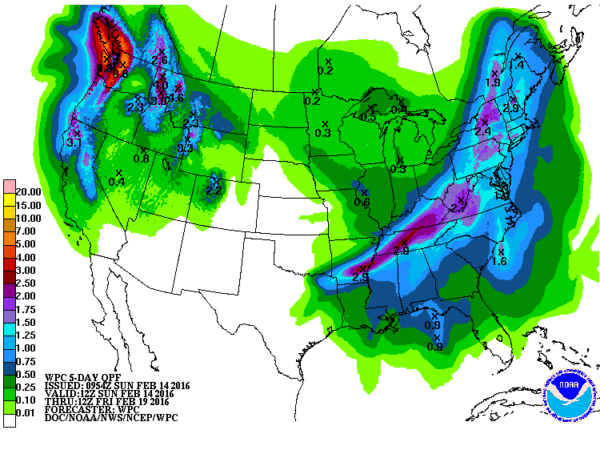
Rainfall for Central Alabama is expected to be around one inch with the heaviest band of 2 to 3 inches from Northwest Mississippi to eastern Kentucky.
For anyone who may be traveling northward from Central Alabama, a band of winter weather advisories and warnings extended from Virginia eastward to Missouri and then northwestward to the Dakotas. These advisories and warnings cover today into the first half of Monday before the precipitation ends. Western and Central Kentucky into Virginia expects 3 to 5 inches of snow while west and northwest snowfall amounts are expected to be less with around 1 to 3 inches possible.
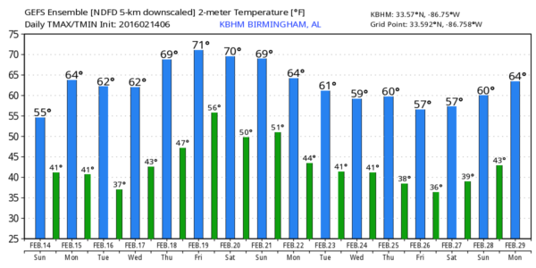
Rain will end in Central Alabama Monday night or very early Tuesday morning. The upper short wave moves quickly into New York with the surface on Tuesday, so we should dry out. While there will be a trough over the East Coast, it will not have the amplitude of the troughs we’ve seen recently, so while our temperatures will cool slightly, values will actually be very close to our seasonal averages with highs in the upper 50s and lows in the middle and upper 30s.
Thursday the upper air pattern becomes dominated by a ridge allowing us to warm into the lower 60s for highs. Another short wave trough comes into the Upper Mississippi River Valley on Friday with a surface low over the western Great Lakes. With a good southerly flow across the Southeast US with a high situated along the East Coast, we should see afternoon temperatures warm well into the 60s.
That trough moves to the Mid-Atlantic States on Saturday while a weak cold front drags into the Southeast US but begins to washout. As I noted yesterday, the GFS wants to produce a few showers for North and Central Alabama, but with precipitable water values fairly low, the chance for any showers seems pretty small. Temperatures for the end of the week and the weekend look pretty nice with lows in the 40s to mid 50s and highs in the 60s with 70s possible across South Alabama.
But don’t get used to those mild to warm temperatures. The GFS promises another shot of cold air with a fairly deep trough over the eastern half of the country around the 24th of February. Once that trough gets established, it remains in place through the end of February so it looks like the month will go out on a somewhat cold note.
I had a great time visiting with folks at the World of Wheels yesterday afternoon. The event continues today, so be sure to drop by the ABC 3340 booth if you can. James Spann will have the next edition of the Weather Xtreme Video first thing on Monday morning, but you can always check by here for notes about Alabama weather. Have a great day and Godspeed.
-Brian-
Category: Alabama's Weather


