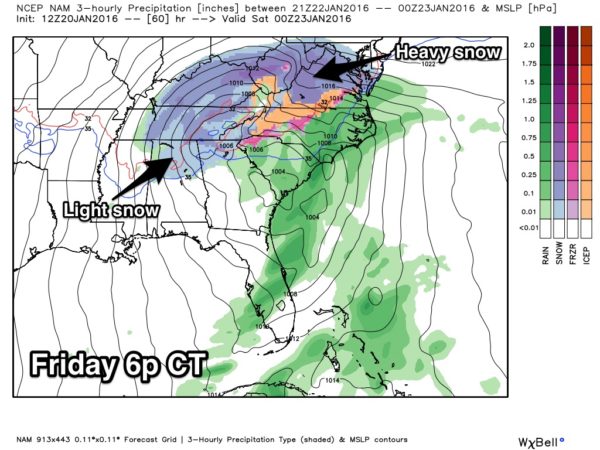
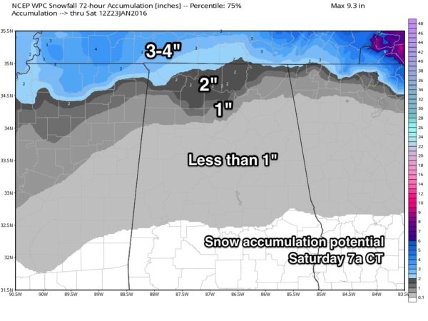
Snow Potential Late Friday/Friday Night
Let’s take a closer look at the situation for Alabama….
Friday will be a day with falling temperatures as the deepening surface low moves northeast, away from us. We should begin the day in the 50s, falling through the 40s during the midday hours, and reaching the 30s by mid to late afternoon.
And, as the cold air rushes into the state, light rain on the back side of the departing storm will change to light snow, or snow flurries by mid to late afternoon.
We should stay well above freezing through the day Friday, so no impact is expected during the day.
FRIDAY NIGHT: Temperatures go below freezing, and I think the course of least regret here is to mention some risk of light accumulation over North Alabama, generally along and north of I-20 (Tuscaloosa to Birmingham to Anniston). By light accumulation I am talking 1/4″ or less for North/Central Alabama… best chance of seeing anything more than that will be on the ridges of East and Northeast Alabama, especially above 1,500 feet. Mt. Cheaha (Alabama’s highest point) could pick up 2-3 inches in a best case scenario for them (their elevation is 2,400 feet).
And, up in the Tennessee Valley of far North Alabama, amounts could exceed 1 inch in spots.
This type situation is usually a low impact one for Alabama, but a few isolated icy patches could develop on bridges and roads Friday night and Saturday morning across the northern counties of the state.
A few lingering snow flurries are possible into Saturday morning.
We all know that forecasting winter weather in Alabama is a challenge; just wanted to put this out this morning, and understand the forecast can, and probably will change by the time we get to Friday night.
Stay tuned.
Category: Alabama's Weather


