Early Morning Notes
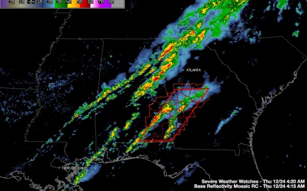
It has been a relatively quiet night across Central Alabama. The tornado watch for this part of the state has expired. A new tornado watch goes until 9 a.m. now for SE Alabama. Counties in the watch in the Birmingham NWS Coverage Area include Barbour, Bullock, Lee, Macon, Pike and Russell
Three distinct lines of showers and storms are occurring across Alabama tonight. The northernmost line is weakening slowly. It is almost perfectly aligned along I-59. The heaviest rain is between Tuscaloosa and Eutaw.
The second line has become dominant. It extends from Dallas, GA to Buchanan to northeast of Ashland to Goodwater to Rockford and Thorsby.
Nothing severe in Alabama, but there is a tornado warning for areas west northwest of Atlanta.
The third line is over Southeast Alabama where a confirmed tornado touched down in Barbour County a short time ago.
The showers and storms will continue for the next few hours as the entire mass of rain sags southeastward ahead of a cold front that has made it to the Northwest Corner of the state. It won’t make it much further though as it will be turning tail and running back to the north later today or tonight as a warm front. More showers and storms will accompany it back to the north.
The SPC has a marginal risk of severe weather for today for all but the Wiregrass area of Southeast Alabama.
Temperatures will continue much above normal through Monday with 70s for daytime highs and mild lows in the upper 60s. Christmas Day looks like it will break a record high for the date with 76F. Sunday will be in record territory as well with a projected high of 75.
Category: Alabama's Weather, Severe Weather


