Warming Commences with Rain Ahead
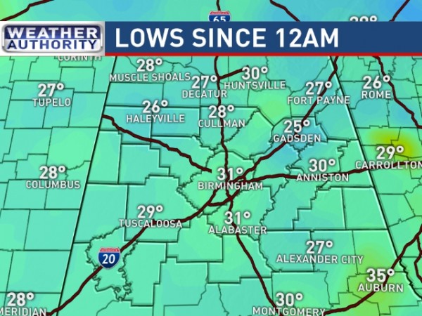
The surface high that was centered near Huntsville last night has migrated east and was situated over Virginia and North Carolina this morning. The sky remained clear, but clouds will be on the increase late today and into Monday. The morning lows were generally in the 28 to 32 degree range while some of the colder spots dipped further into the 20s. Our Skywatcher at Black Creek recorded a low of 23 at last report. Sunshine this morning should take the chill off fairly quickly with the highs today climbing to near 60.
Monday will see cloudy skies along with rain chances on the increase as an upper trough scoots by in the southwesterly flow aloft. With a southerly flow near the surface and moist southwesterly flow aloft, we should see the atmosphere moisten up quickly on Monday with precipitable water values climbing to near 1.5 inches and surface dew points coming back into the lower 50s. Scattered showers or light rain become possible by Monday afternoon with highs warming into the lower 30s.
The upper air pattern will remain stuck with a trough in the West and a ridge just off the Atlantic Coast through next weekend. With the upper flow tapped into Pacific moisture and a continual southerly flow at the surface, our precipitable water values should climb to near 2 inches which is way higher than averages for this time of year. The front will coast into North Alabama on Christmas Eve but lose forward progress as it becomes parallel to the upper flow. That front will likely move back north on Christmas Day as a warm front, so I expect us to stay open the warmer side of the front. With rain and clouds, morning lows will not drop back much with lows by Wednesday and Thursday in the lower 60s. Without much sunshine due to the clouds, daytime highs will likely reach the lower 70s.
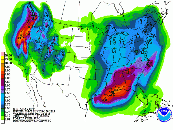
There are several questions to be answered that cannot be answered with confidence just yet. One is the potential for severe weather. SPC has drawn an area for potential severe weather in the Lower Mississippi River for Day 4, Wednesday into Thursday morning, just to our west. The GFS also seems to be bullish on the idea of thunderstorms along the coast. These thunderstorms could well interrupt the southerly flow of low level moisture enough to keep us from experiencing severe weather. Then there is the potential for flash flooding or flooding. The QPF outlook has increased from yesterday with a fairly large area of 2 to 4 inches of rain possible through early Christmas morning. With the relatively dry conditions for the past week, we can probably handle that much rain without any serious issues. But we’ll have to be vigilant for any training of storms which could present flash flooding issues.
Christmas Day will be warm for us with a chance of showers. Highs will be in the lower 70s, so it will be warm enough to get outside to enjoy any presents that came under the tree.
Rain chances are likely to go up into next weekend as the closed low over northern Mexico finally begins its trek eastward. The GFS projects it coming through the Lower Mississippi River Valley on Monday. This may well present a severe weather threat especially along the Gulf Coast with a surface low projected to develop in the Northwest Gulf and move across South Alabama on Monday. This verges into voodoo country, so it is likely to remain something to watch.
Plenty of sunshine and cool weather prevails at the beach today, but clouds increase Monday. Rain chances also go up on Monday and stay with us until Christmas Eve. Isolated showers are forecast for Christmas Day. Temperatures will be warmer during the week ahead with highs in the 70s and lows in the 60s. See the complete Gulf Coast 7 Day Planner here. The Gulf Coast Beach Forecast is presented by Gulf Shores Plantation by Mandoki Hospitality Vacation Rentals. Escape to Gulf Shores Plantation where memories last a lifetime.
Looking further into voodoo country, the GFS brings another upper trough and closed low into the Southwest US at the end of December that looks a lot like the pattern we’re dealing with this coming week. But by the end of the forecast period around the 4th of January, the pattern shows a trough over the eastern US with a coolish – but not extremely cold – look for the start of the new year.
James Spann will be back with the next edition of the Weather Xtreme Video first thing Monday morning. Check back here often for updates on the weather for Central Alabama.
-Brian-
Category: Alabama's Weather


