Mild Afternoons, Cool Nights
DELIGHTFUL DECEMBER AFTERNOON: Temperatures are generally in the low to mid 60s across North/Central Alabama this afternoon, a little above the average high of 58 for December 7. No rain on radar, and the sky is mostly clear.
Tonight will be clear and chilly; we project a low in the mid to upper 30s for most communities early tomorrow; colder pockets could see a light freeze.
TOMORROW THROUGH FRIDAY: We stay dry, with mild afternoon and cool nights. We reach the mid 60s tomorrow and Wednesday, upper 60s Thursday, and low 70s Friday. Lows Wednesday, Thursday, and Friday morning will be in the 40s. Partly to mostly sunny days, fair nights.
SATURDAY: The GFS is printing a high of 72 degrees for Birmingham Saturday afternoon… not too far away from the record high of 78 for December 12, set in 1971. The day will stay dry with a mix of sun and clouds.
STORMY SUNDAY? The primary American computer model, the GFS, shows a band of showers moving through the state Sunday, but the European model (the ECMWF), which has performed well this year in the medium range, still shows a more vigorous system. That solution involves a deep surface low moving from southern Missouri up to near Chicago Sunday night, supported by a deep upper trough to the west.
The Euro shows dewpoints surging up into the upper 60s Sunday afternoon, and surface based CAPE (instability) up to 1,000 j/kg. This will bring an environment favorable for strong to severe thunderstorms late Sunday and Sunday night. If the model verifies, the prime risk would come from strong straight line winds along a squall line that will pass through the state, and the core risk will come from 4:00 p.m. Sunday through 4:00 a.m. Monday.
However, there is still a good amount of uncertainty here, so be sure and keep up with the latest blog posts for potential forecast changes in coming days.
NEXT WEEK: For now the weather looks dry and cool Monday through Wednesday with highs in the 50s and lows in the 30s and 40s… another chance of rain returns Thursday. See the Weather Xtreme video for maps, graphics, and more details.
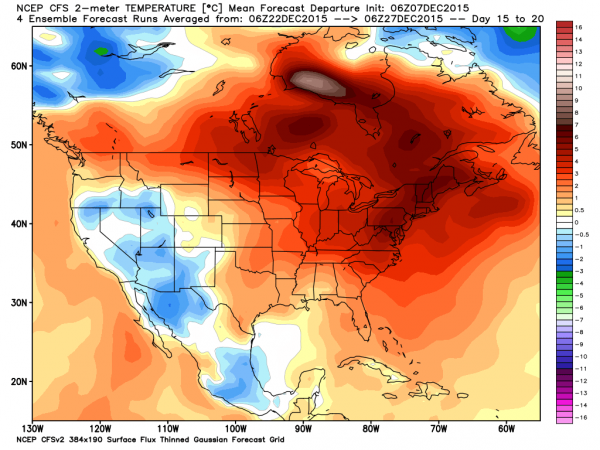
MILD CHRISTMAS? Long range guidance from the CFS (Climate Forecast System) hints the eastern half of the nation won’t be especially cold late this month, which is fairly typical of an El Nino winter.
AT THE BEACH: Mostly sunny mild days, fair cool nights on the coast from Panama City Beach over to Gulf Shores through Friday… next decent chance of showers will come Sunday. See the complete Gulf Coast 7 Day Planner here. The Gulf Coast Beach Forecast is presented by Gulf Shores Plantation by Mandoki Hospitality Vacation Rentals. Escape to Gulf Shores Plantation where memories last a lifetime.
WEATHER BRAINS: Don’t forget you can listen to our weekly 90 minute netcast anytime on the web, or on iTunes. This is the show all about weather featuring many familiar voices, including our meteorologists here at ABC 33/40. We will produce this week’s show tonight at 8:30 CT… you can watch online here.
CONNECT: You can find me on all of the major social networks…
Facebook
Twitter
Google Plus
Instagram
I had a great time today visiting with the 5th graders at Southside Elementary Schoo…. be looking for them on the Pepsi KIDCAM today at 5:00 on ABC 33/40 News! The next Weather Xtreme video will be posted here tomorrow morning by 7:00…
Category: Alabama's Weather


