There’s a Chill on the Way!
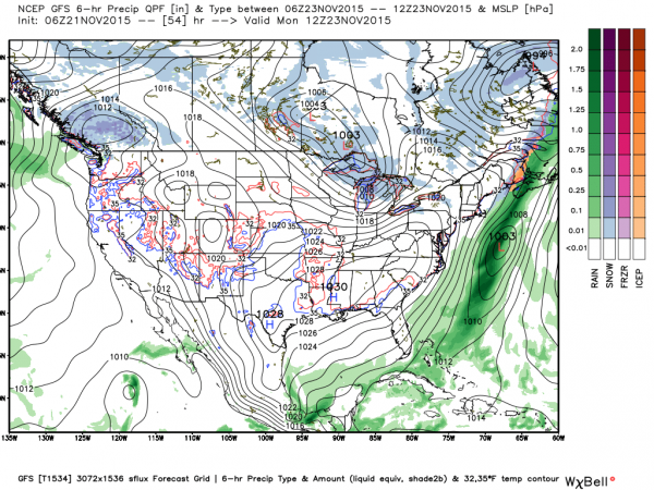
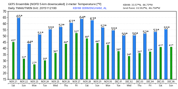
A cold front was positioned early this morning to cross the Mississippi River with a low pressure cuter located over southern Illinois. Snow was causing some travel issues from eastern Iowa across the southern portion of Lake Michigan and much of the Lower Peninsula of Michigan. No snow for Central Alabama, but with the front expected to move briskly across the Southeast US today, we are expecting a major chill down as temperatures fall from the 60s into the 30s for Sunday morning. Cold air will continue to flow into the Southeast Sunday with the afternoon highs struggling to get out of the 40s. A freeze warning was posted for just about all of Central Alabama from 9 pm Sunday night to 9 am Monday morning.
Little frost is expected tonight and early Sunday since we expect the wind to stay up in the 6 to 12 mph range. This will keep the layer of air near the ground mixed and should be enough to keep frost from forming. But that all changes on Monday morning as the surface high settles over the Southeast US allowing for good radiational cooling with the wind dropping off to near calm. Cold air advection, calm wind, and good radiational cooling will allow them temperatures on Monday morning to fall into the 20s for most of Central Alabama. You’ll definitely need a jacket and perhaps some extra time to scrape the ice off your windshield for those parking cars outside.
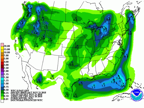
As you might expect with conditions becoming so cold, there is no areas of severe weather forecast by SPC. And the tropical Atlantic remains quiet with about 10 days left in the 2015 hurricane season.
If you are a football enthusiast, you know that Alabama and Auburn are both at home this weekend, but they’re probably looking a little ahead to the big IRON BOWL showdown next weekend. But for today, Alabama hosts Charleston Southern at Bryant-Denny Stadium with a 3:00 pm CST kickoff; the sky will be a mix of sun and clouds with a small risk for a shower during the game. Temperatures falling from around 67 degrees at the start of the game, into the lower 50s by the final whistle. At the same time Auburn will host Idaho at Jordan-Hare Stadium. There will be some scattered clouds along with a small risk of a shower. Temperatures near 63 at kickoff, dropping into the lower 50s by the end of the game.
If you’re taking your football with a taste of sand, it looks mostly dry from Dauphin Island all the way to Panama City Beach for the whole Thanksgiving week. Nights will turn cold Sunday through Tuesday with morning lows in the 40s. See the complete Gulf Coast 7 Day Planner here. The Gulf Coast Beach Forecast is presented by Gulf Shores Plantation by Mandoki Hospitality Vacation Rentals. Escape to Gulf Shores Plantation where memories last a lifetime.
Late Monday the upper air pattern begins to shift as we start a nice warmup for Thanksgiving week which will remain dry. Monday our upper flow begins to go from northwesterly to westerly as a ridge develops over the eastern half of the US in response to a digging trough over the western US. This pattern will remain through Black Friday so we stay with a southwesterly flow allowing our highs to climb well into the 60s with morning lows in the 40s for the latter half of the week.
The ridge is progged to force the western trough to lift out across the Great Lakes, but as the surface low moves into Canada, a cold front will drag into the Southeast US beginning Friday. Due to the position of the surface low and west-southwest flow aloft, the front will be taking its time moving across the Southeast US, so I expect to see our best rain chances to come late in the day Friday and into Saturday. Since this is verging on voodoo country, the timing for the rain may need to be adjusted for increases or decreases in the speed of the primary features.
Voodoo country remains active. A closed low digging all the way into northern Mexico around December 3rd will keep the Southeast US in fairly mild temperatures. But that all changes around the 5th of December with the transition of a deep trough across the eastern US which could spell another period of cold temperatures in the 5th through 7th time period.
I’m going to be heading the Chaser down to Tuscaloosa for Thanksgiving in the Street on the west side of town. Maybe you’ll have a chance to come by and say hello. I plan to have the next Weather Xtreme Video posted here first thing Sunday morning. Enjoy this day and the great temperatures since colder weather is just around the corner. Godspeed.
-Brian-
Category: Alabama's Weather


