Cold Front Arrives This Weekend
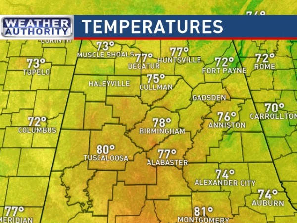
WARM NOVEMBER AFTERNOON: Tuscaloosa has soared to 80 degrees this afternoon… within 3 degrees of their record high for November 4. Most other communities are in the mid to upper 70s.
Nothing on radar, and we have a mix of sun and clouds across the state.
TOMORROW: No real change; morning clouds giving way to some afternoon sun, and a high between 77 and 80 for most places. Any afternoon showers will be few and far between. To the west, strong to severe storms are possible from Texas to the Great Lakes ahead of the big upper trough out west lifting northeast.
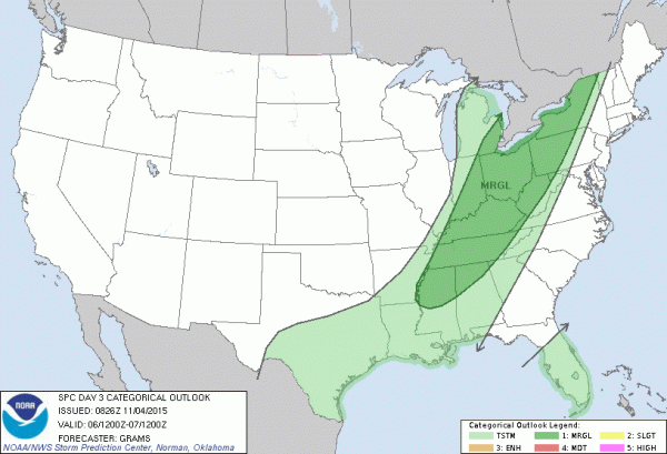
FRIDAY: Another warm November day with a high very close to 80, but we expect an increase in the number of showers and thunderstorms by late afternoon and into Friday night with the approach of a surface cold front. SPC has the northern third of the state in a “marginal” severe weather risk; we will watch radar trends closely, but it doesn’t look like a classic severe weather setup.
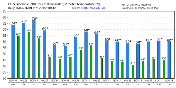
THE ALABAMA WEEKEND: The front will hang up near the Alabama/Tennessee border Saturday, meaning the weekend begins with wet weather. We expect periods of rain and a few thunderstorms through Saturday night; severe weather isn’t expected, and rain amounts of 1 to 2 inches are likely. It won’t rain all day Saturday, but the rain could come at any time. The high Saturday afternoon will be in the 67-70 degree range.
Drier and cooler creeps into North Alabama Sunday; there could be a few lingering showers Sunday morning, especially south of I-20. The GFS is printing a high of only 61 degrees for Birmingham Sunday afternoon.
NEXT WEEK: For now we will leave the forecast alone for Monday and Tuesday, dry and cool both days with highs in the 60s. We do note the GFS 12Z run shows an easterly fetch of moisture moving into the state with some threat of light rain, but for now that is an outlier and is rejected.
A significant storm system will push a cold front through here at mid-week, and we will have a round of showers and storms late Wednesday night or Thursday. Models are not consistent with the details on this system; we will keep an eye on severe weather potential as it gets closer. We are now in our fall severe weather/tornado season (November/December). See the Weather Xtreme video for maps, graphics, and more details.
FOOTBALL WEATHER: For the high school playoff games in Alabama Friday night, showers and thunderstorms are a good possibility, and a few lightning delays are possible. Temperatures will be in the mid to upper 60s at most stadiums.
The biggest college game in the nation is Saturday night when LSU takes on Alabama at Bryant-Denny Stadium (7:00p CT kickoff). A cold front will be just north of Tuscaloosa, and it is a close call with dry air trying to push in from the north. But, new model runs keep the front to the north, and we will forecast a good chance of rain at times during the game, with a thunderstorm possible as well. Temperatures will fall through the 60s, perhaps reaching the upper 50s by the final whistle.
Auburn is in College Station to take on the Aggies of Texas A&M Saturday night (6:30p CT kickoff)… it is beginning to look like the bulk of the rain will be over by the time this one begins, but we will hang on to the risk of a few stray showers during the first half. Temperatures will fall through the 60s.
AT THE BEACH: Dry weather for the coast from Gulf Shores over to Panama City Beach through tomorrow, then some risk of scattered showers or thunderstorms Friday through the weekend with a limited amount of sunshine. See the complete Gulf Coast 7 Day Planner here. The Gulf Coast Beach Forecast is presented by Gulf Shores Plantation by Mandoki Hospitality Vacation Rentals. Escape to Gulf Shores Plantation where memories last a lifetime.
WEATHER BRAINS: Don’t forget you can listen to our weekly 90 minute netcast anytime on the web, or on iTunes. This is the show all about weather featuring many familiar voices, including our meteorologists here at ABC 33/40.
CONNECT: You can find me on all of the major social networks…
Facebook
Twitter
Google Plus
Instagram
Look for the next Weather Xtreme video here by 7:00 a.m. tomorrow…
Category: Alabama's Weather


