Turning Wet Yet Again
Additional delays with the video thanks to problems with YouTube.
Let’s start off with a marvelous sunset picture over Weiss Lake taken by Teresa Sauls that James retweeted yesterday afternoon. What a great ending to a week that started wet. And unfortunately we are heading into another rainy period for Central Alabama with rain chances not expected to end until Monday.
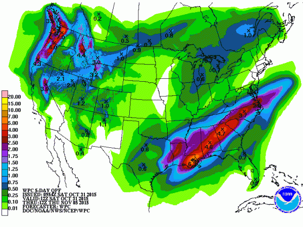
Temperatures across Central Alabama were up this morning thanks in part to the advancement of clouds last night and early this morning ahead of the system which is expected to bring rainfall on the order of 1 to 4 inches across the state. We do start the day out dry this morning, but the clouds arrived overnight, so I don’t expect to see much sunshine this weekend. We’re going to have to wait until Tuesday for some rays!
The upper air flow featured a ridge just off the East Coast of the US with a deep trough extending from Wisconsin to the south and turning southwest over West Texas and northern Mexico. This is setting up a moisture rich southwesterly flow from South Texas to the southern Appalachians. The upper trough will take its time coming out of the southwest finally edging past Alabama late in the day Monday. Meanwhile, a surface low pressure located over Southeast Texas this morning will slowly move into the southern Appalachians by Monday bringing widespread rain to all of the Lower Mississippi Valley and the Southeast US. Clouds and rain will keep Central Alabama in the 60s today and Sunday with little difference between lows and highs. We could see some peeks at the sun by late Monday afternoon when we should also see the highs climb out of the 60s but only into the lower 70s.
A check of the radar this morning showed a few patches of very light rain, however, the sounding from BMX last night showed a dry atmosphere from 900 to 400 millibars so very little of that light rain is reaching the ground. Rain was occurring west of the Mississippi River and extended back into Central Texas. Rain is expected to advance eastward today reaching the Birmingham area in the 2 to 5 pm time frame. Once rain starts, we should see rain off and on until Monday when the rain, but not the clouds, is expected to move east of us.
Instability appears likely to be confined to the Gulf Coast area, so while we may hear some thunder, no severe weather is expected in Central or North Alabama. SPC has the slight risk for Day 1 drawn across southern Louisiana and extreme Southeast Texas. On Day 2, a marginal risk exists across Southwest Alabama and the western sections of the Florida Panhandle extending up to the I-85 corridor and covering Southeast Alabama.
Rain will be the big concern for Alabama with rainfall totals potentially exceeding 4 inches in places. Rainfall through Sunday morning could be around 2 inches in southwest counties of Alabama with amounts decreasing to around a half inch for counties in the extreme northeast corner. Rainfall on Day 2 ending at 12Z Monday morning (6 am) will add 2 to 3 inches to whatever falls today. Rain amounts fall off quickly on Monday. And right now it sure seems likely that trick or treaters will be washed out except for the counties along the Georgia border.
For football enthusiasts, the Auburn Tigers entertain the Ole Miss Rebels in an SEC skirmish on the Plains at 11 am. The weather will be cloudy but rain should hold off until after the final whistle. Temperatures will rise through the upper 60s and lower 70s topping out near 73 about the final whistle. In Birmingham for today’s Magic City Classic, the sky will be cloudy for the kickoff between Alabama State and Alabama A&M at Legion Field at 2:30 pm. Temperatures will fall from the upper 60s at kickoff into the middle 60s by the fourth quarter. It still looks like rain could move into Birmingham during the game with best chances for rain coming during the second half.
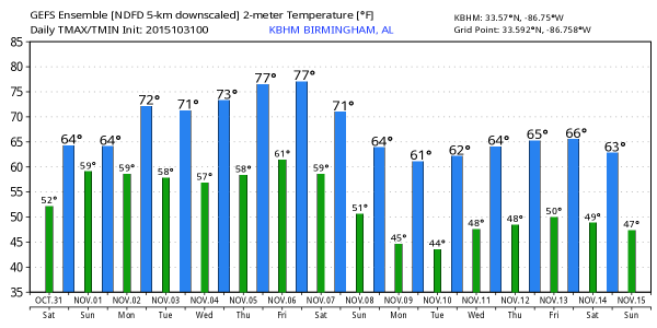
Rain will also be the rule for the beach areas of South Alabama and the Florida Panhandle. A flash flood watch includes Southwest Alabama until Sunday afternoon, and there could be changes in the areal coverage and time frame for this watch. Thunderstorms are also likely for the beach areas through Sunday. Rain moves out Monday and the temperatures for the next week should be fairly nice with highs in the 70s and lows in the 60s.
Ridging aloft takes hold on Tuesday and will be the primary player in our weather from mid-week to the start of next weekend. We should see some sun and clouds mixed with lows in the upper 50s and lower 60s while afternoon highs will be very pleasant with readings in the middle and upper 70s.
The next chance of rain could come next Saturday, but since we have a lot on our plates now and that is verging on voodoo country, we’ll hold off on any firm forecasts for rain for now.
The longer range pattern remains active with another shot at rain about the 11th of November. The GFS is advertising a potent trough that even appears to go negatively titled around the 13th/14th time frame. If this solution comes to fruition, we could see a strong severe weather episode. But no need to worry just yet since that really is a long way out.
I expect to have the next edition of the Weather Xtreme Video on Sunday morning. Be sure to check it out when we should be able to provide an answer to the question, when will the rain end? In the meantime, be safe and stay dry! Godspeed.
-Brian-
Category: Alabama's Weather


