Waiting on the Rains
If you are a weather enthusiast, then you have probably been watching the drama unfolding as the strongest hurricane ever, Patricia, has made its way ashore south of Puerto Vallarta. And now it looks like Patricia will play a role in our weather as things turn wet for the first of next week.
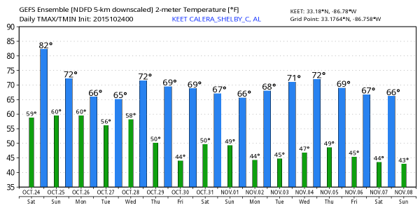
The sky has become increasingly cloudy overnight which has helped to influence temperatures tremendously with the morning lows today primarily in the middle and upper 60s, about 12 to 15 degrees above the seasonal values we usually see for the latter part of October. Rain ahead of Patricia will move closer to Alabama but it looks like it will stay away until late on Sunday and into early Monday morning.
If you are headed for Tuscaloosa where Alabama will host Tennessee at 2:30 pm today, the sky will be mostly cloudy, but dry. While we can’t completely rule out a stray shower, there is nothing significant expected. Temperatures will drop from near 80 at kickoff into the mid 70s by the final whistle. And Auburn is on the road as they travel to Fayetteville to take on the Arkansas Razorbacks at 11:00 am. The day will be cloudy but it looks like most of the rain has moved south and east of Fayetteville so the game should be dry. Temperatures will be in the lower 60s with a northwesterly breeze.
For the races at Talladega, the sky will be mostly cloudy today and Sunday. We can’t rule out a brief shower or a touch of light rain Sunday, the most widespread rain should stay west of the track Sunday arriving early Monday morning. Temperatures will peak around 80 today and in the mid to upper 70s Sunday.
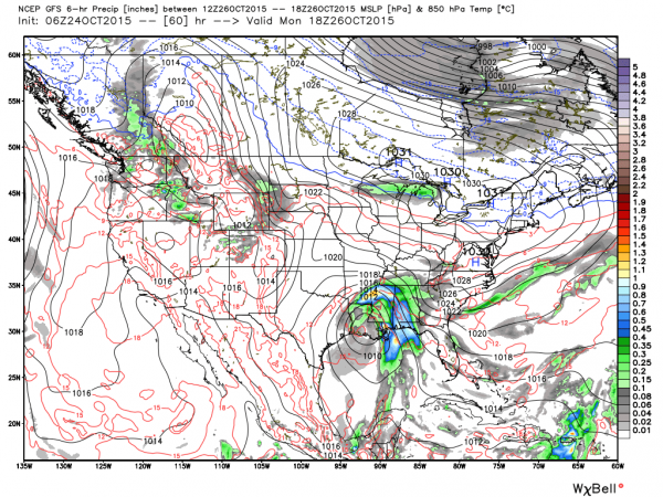
Monday we start the week out wet as the remains of Patricia move slowly northeastward. The future course of these remains is still somewhat uncertain. The Euro and GFS continue to bring those remains over the extreme Northwest Gulf but very close to the Texas coastline. Water temperatures in this area are about 3 to 5 degrees C colder than what Patricia enjoyed off the Mexican coast. This together with the center of the low remaining close to the coastline, it would be unlikely that the remains would be able to gather much strength. It is still possible that the remnant low could become a depression or maybe a tropical storm, but unlikely that it could gain enough strength to become a hurricane. Plus, if the center of the remnant low remains over land, little intensification is likely. But in that same vein, if it moves over the Gulf further from shore, it would have somewhat better chances for development.
No matter what it does, rain is going to cover much of the Lower Mississippi River Valley and the Southeast for Monday and Tuesday with rainfall amounts over Alabama potentially in the 2 to 3 inch range. And as we know, any deviation of the storm centers track even a little could raise or lower those values. Since we’ve had nearly two full weeks without rain, the potential for flash flooding remains low but not zero.
An upper air trough should swing through the Central US Tuesday and Wednesday and push what’s left of Patricia northeast away from the Southeast US ending our rain temporarily. We should see a slight warming for the end of the week as we come under an upper ridge. But the moist southwesterly flow ahead of another trough aloft Saturday and Sunday promises some more rainfall for late in the weekend and into week 2.
Voodoo country shows some potential for both wet weather and a significant cold shot. A trough comes out early in week 2 to bring rain chances. But by the end of the week as we head into November, a deep trough is forecast over the eastern US which could spell both a round of severe weather as well as a substantial chill down.
I expect to have the next Weather Xtreme Video here Sunday morning. I’m enjoying some time in Chicago with my daughter, so it may not get posted real early on Sunday morning. Enjoy the day and Godspeed.
-Brian-
Category: Alabama's Weather


