Clouds Hang Tough, But Mainly Dry
The upper low that is causing historic and catastrophic flooding in South Carolina is pushing eastward out of southern Georgia this afternoon. Some parts of the Palmetto State have received over twenty inches of rain in the past few days. One COCORaHS observer near Mount Pleasant SC, near Charleston, has received over 24 inches of rain in the past four days. There are numerous reports of life threatening flooding across South Carolina, including dam failures, washed out bridges and building collapses.
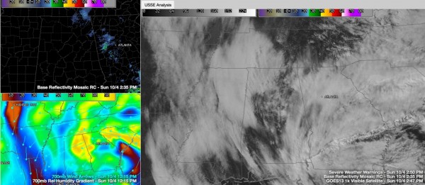
Nothing like that here, although the moisture wrapping around the low is he;ping to enhance the clouds across our area. Other moisture has been wrapping down from the north and covers West Central Alabama and much of Mississippi. In between, some sinking air on the left side of the low has allowed for some clearing. In areas that have seen more clearing, some stratocumulus clouds were forming under the cold temperatures aloft, which make for slight instability.
Not enough for showers though. And the only precipitation has been some light rain over Northeast Alabama.
Temperatures are in the upper 60s to lower 70s.
Expect increasing sunshine as we head into Monday. Temperatures will be heating up as well and we should see a seasonable, dry week ahead.
HURRICANE JOAQUIN
Hurricane Joaquin is 125 miles west southwest of Bermuda at this hour. Top winds are still 105 mph, making it a Category Two hurricane. Winds have gusted to 55 mph on the island. The barometer is down to 29.35. Hurricane warnings are in effect, but I think the island may escape without officially measuring hurricane force winds.
Category: Alabama's Weather


