Another Hot One
HOT, HOT, HOT: Monday was another hot day across Central Alabama. It was not the hottest day so far in 2015, but it wasn’t far away from it either. First order station highs ranged from 95F at Calera to 96F at Anniston to 97F at Birmingham to 99F at Tuscaloosa. Readings today will be about like those of yesterday, so you can take heart in the fact that it is not the hottest day of the year. Cool comfort though, since when you get this close to 100F, it is hard to tell the difference.
RAIN CHANCES TO INCREASE: A handful of paltry thunderstorms did manage to develop over the Northwest Corner of the state late yesterday afternoon, but they were short lived and very isolated in nature. The same will be the case today. But after today, rain chances will be ramping up as a longwave trough continues to be carved out over the eastern United States. A shortwave trough will ride southeastward along the base of the trough from Missouri late Wednesday into Thursday. Scattered showers and storms will reappear tomorrow, and become more likely on Thursday and Friday as the disturbance passes and a cool front approaches from the north.
WEEKEND OUTLOOK: The front will slide through the area on Saturday, delivering one more round of showers and storms. Then things should begin to dry out behind the front on Sunday.
NEXT WEEK: The heat ridge will really strengthen to our west next week, keeping us in a northwesterly flow aloft. This will provide chances for complexes of showers and thunderstorms to be spit at us from the Midwest.
VOODOO COUNTRY: Going out to August 19th, the GFS still shows a big trough over the eastern United States. We stay unsettled and cooler than average.
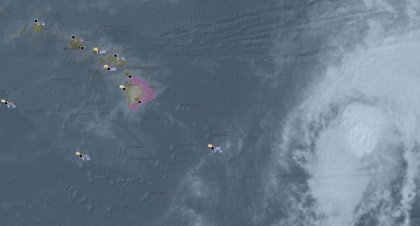
TROPICS: The low over the northeastern Gulf of Mexico moved inland over northern Florida yesterday, pre-empting the potential for a tropical depression to form. The NHC is still tracking it, but the chance of future development is low. Over the Central Pacific, Tropical Storm Guillermo is pass just north of the Hawaiian islands on Wednesday. High surf advisories are in effect for east facing shores of the Big Island. Winds won’t be especially strong, but seas will be high and up to three quarters of an inch of rain is expected with the system.
WEATHERBRAINS: The show that will was released into the wild last night was recorded ten days ago. It features a great interview with Rebecca Brandes-Gratz, the Author of “We’re Still Here Ya Bastards: How the Citizens of New Orleans Rebuilt Their City After Hurricane Katrina”. Check out the show at www.WeatherBrains.com. You can also subscribe on iTunes.
ON THIS DATE IN 1980: Dallas finally saw its incredible string of 42 straight days with temperatures over 100 degrees broken on this date. There would be 18 more 100 plus days in August and 4 more in September. The month of July was the hottest ever in the Big D. There would be no measurable rain in the month at Dallas. The tremendous heat wave and drought that summer killed 1200 people across the nation. Losses reached $200 million.
AND ON THIS DATE IN 1998: Dallas saw its streak of 29 consecutive days with temperatures 100 degrees or hotter at DFW come to an end. It was the second longest streak of 100 degree plus days in the city’s history, coming in second to the 42 straight days from 1980 that strangely ended on the same date.
JAMES RETURNS TOMORROW: Spann will be back in the swing with two videos tomorrow. Have a great Tuesday and try to stay cool!
Category: Alabama's Weather


