Big Storms in Birmingham Metro
Storms have blown up in the past few minutes over southern Birmingham from Homewood to Mountain Brook.
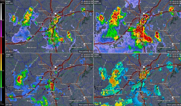
This image show base reflectivity (precip near the ground) in top left, composite reflectivity (good indicator of where is is about to storm heavily) in the top right, cloud heights in bottomr right and one hour rainfall amounts in bottom left.
An arc from Irondale to Helena has not filled in almost completely with the intense storms. They are approaching I-459 from Liberty Park to 280 and are already over the interstate in the Hoover area.
Torrential rains and deadly lightning are occurring with the storms. There will be some quick urban flooding and gusty winds as well. There is even some small hail in Homewood. The thunder is really booming. And remember, when thunder roars, go indoors.
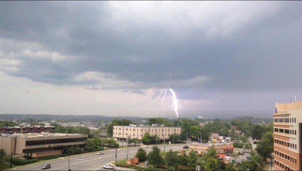
@jaime_626 took this breathtaking photo from St. Vincent’s Hospital. You don’t want to be anywhere near a bolt like that!
An areal flood advisory has been issued for parts of Jefferson County. You can see some two inch rainfall amounts in the past hour over Riverchase into the Hoover area. Some 1.5+ inch amounts are along the Jefferson/Walker County line.
The storms extend down to Columbiana in Shelby County with others forming between Columbiana and Childersburg. More storms are over western Jefferson County along the Walker County line extending back into northeastern Tuscaloosa County.
Category: Alabama's Weather


