Moist Air Returns Tomorrow
A NICE TOUCH OF FALL: We are seeing mid 50s this morning across Northeast Alabama… some reports at daybreak…
Black Creek (just northeast of Gadsden) 54
Fort Payne 55
Valley Head 57
Cullman 59
Cottondale 59
Scottsboro 59
Haleyville 61
Anniston 62
Center Point 63
Tuscaloosa 65
Birmingham 65
Humidity levels will stay rather low today, and we expect a high close to 90 degrees in most spots this afternoon. We will mention the risk of widely scattered showers late in the day, mainly north of U.S. 278 (Hamilton to Cullman to Gadsden).
TOMORROW THROUGH FRIDAY: Moist, maritime tropical air returns to the state with higher humidity values and warmer nights. And, each day we will have to dodge scattered showers and thunderstorms. It is impossible to give you specific start/stop times due to the random nature of the showers, but the higher chance of them will come during the afternoon and evening hours… but we can’t totally rule out a late night or morning shower along the way. Afternoon highs will be generally in the 86 to 89 degree range, and there will be some decent intervals of sunshine away from the showers and storms.
FOURTH OF JULY WEEKEND: No real change; expect a mix of sun and clouds Saturday and Sunday with the risk of scattered, mostly afternoon and evening showers and thunderstorms. Highs in the 87 to 90 degree range. Chance of any one spot seeing a storm is about 50/50 both days.
And, expect similar weather into early next week with highs creeping up into the low 90s.
AT THE BEACH: We have a very standard mid-summer forecast for the Central Gulf Coast through the upcoming holiday weekend. About 7 to 9 hours of sunshine each day, with the risk of an occasional passing shower or storm. Highs on the immediate coast will be in the mid to upper 80s, and closer to 90 degrees inland. The sea water temperature this morning at the Dauphin Island Sea Lab is 83 degrees.
TROPICS: A large amount of dry air continues to cover the tropical Atlantic basin, and tropical storm formation is not expected this week.
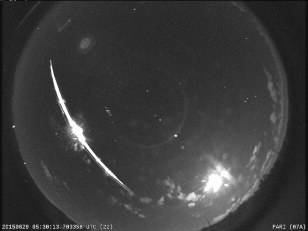
SOUTHERN FIREBALL: Looks like some kind of space debris entered the atmosphere over us very early this morning around 12:30 a.m. Info below is from Bill Cooke at the NASA Meteoroid Environments Office in Huntsville…
“There was a bright event seen over several SE states around 12:29:30 AM CDT – We also picked it up on our meteor cameras. The object moved too slow for meteor (only 14,500 mph), was visible for over 30 seconds, and fragmented into multiple pieces, suggesting that it was possibly a re-entering piece of space junk. The Department of Defense keeps track of such critters, so they would be the ones to confirm this.”?
WEATHER BRAINS: Don’t forget you can listen to our weekly 90 minute netcast anytime on the web, or on iTunes. This is the show all about weather featuring many familiar voices, including our meteorologists here at ABC 33/40. We will produce this week’s show tonight at 8:30 CT… you can watch it on “James Spann 24/7” on cable systems around the state, or on the web here.
CONNECT: You can find me on all of the major social networks…
Facebook
Twitter
Google Plus
Instagram
I will be speaking this morning at the HighEdWeb conference at the University of Alabama in Tuscaloosa… look for the next Weather Xtreme video here by 4:00 this afternoon. Enjoy the day!
Category: Alabama's Weather


